You are here: Home > Network List > IU - Global Seismograph Network (GSN - IRIS/USGS) Stations List
> Station POHA Pohakuloa, Hawaii, USA > Earthquake Result Viewer
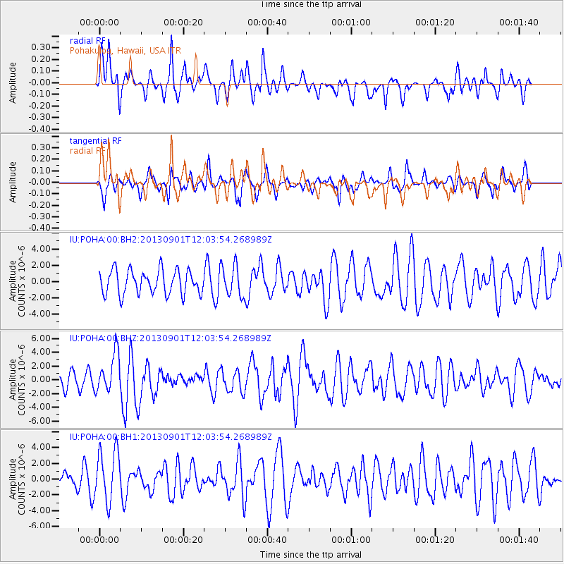
POHA Pohakuloa, Hawaii, USA - Earthquake Result Viewer
*The percent match for this event was below the threshold and hence no stack was calculated.
| Earthquake location: |
Banda Sea |
| Earthquake latitude/longitude: |
-7.4/128.2 |
| Earthquake time(UTC): |
2013/09/01 (244) 11:52:29 GMT |
| Earthquake Depth: |
112 km |
| Earthquake Magnitude: |
6.5 MWW, 6.4 MWC, 6.4 MWD, 6.5 MWW, 6.5 MWB, 6.5 MWC |
| Earthquake Catalog/Contributor: |
NEIC PDE/NEIC COMCAT |
|
| Network: |
IU Global Seismograph Network (GSN - IRIS/USGS) |
| Station: |
POHA Pohakuloa, Hawaii, USA |
| Lat/Lon: |
19.76 N/155.53 W |
| Elevation: |
1990 m |
|
| Distance: |
79.7 deg |
| Az: |
68.409 deg |
| Baz: |
258.249 deg |
| Ray Param: |
$rayparam |
*The percent match for this event was below the threshold and hence was not used in the summary stack. |
|
| Radial Match: |
56.943115 % |
| Radial Bump: |
400 |
| Transverse Match: |
44.74724 % |
| Transverse Bump: |
351 |
| SOD ConfigId: |
626651 |
| Insert Time: |
2014-04-18 07:21:01.831 +0000 |
| GWidth: |
2.5 |
| Max Bumps: |
400 |
| Tol: |
0.001 |
|
Signal To Noise
| Channel | StoN | STA | LTA |
| IU:POHA:00:BHZ:20130901T12:03:54.268989Z | 2.6006293 | 2.8557745E-6 | 1.098109E-6 |
| IU:POHA:00:BH1:20130901T12:03:54.268989Z | 2.0282679 | 3.3167246E-6 | 1.6352498E-6 |
| IU:POHA:00:BH2:20130901T12:03:54.268989Z | 1.3092109 | 1.9313893E-6 | 1.4752317E-6 |
| Arrivals |
| Ps | |
| PpPs | |
| PsPs/PpSs | |


