You are here: Home > Network List > UW - Pacific Northwest Regional Seismic Network Stations List
> Station PASS Maple Falls, WA, USA > Earthquake Result Viewer
PASS Maple Falls, WA, USA - Earthquake Result Viewer
| Earthquake location: |
Kermadec Islands Region |
| Earthquake latitude/longitude: |
-29.0/-176.4 |
| Earthquake time(UTC): |
2013/09/01 (244) 19:50:39 GMT |
| Earthquake Depth: |
10 km |
| Earthquake Magnitude: |
5.7 MWW, 5.7 MWB, 5.7 MWW, 5.8 MWC |
| Earthquake Catalog/Contributor: |
NEIC PDE/NEIC COMCAT |
|
| Network: |
UW Pacific Northwest Regional Seismic Network |
| Station: |
PASS Maple Falls, WA, USA |
| Lat/Lon: |
49.00 N/122.09 W |
| Elevation: |
174 m |
|
| Distance: |
91.5 deg |
| Az: |
32.354 deg |
| Baz: |
225.363 deg |
| Ray Param: |
0.04159377 |
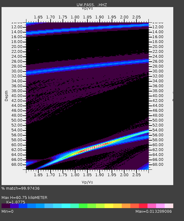
| Estimated Moho Depth: |
60.75 km |
| Estimated Crust Vp/Vs: |
1.88 |
| Assumed Crust Vp: |
6.566 km/s |
| Estimated Crust Vs: |
3.497 km/s |
| Estimated Crust Poisson's Ratio: |
0.30 |
|
| Radial Match: |
99.97436 % |
| Radial Bump: |
7 |
| Transverse Match: |
96.79651 % |
| Transverse Bump: |
279 |
| SOD ConfigId: |
626651 |
| Insert Time: |
2014-04-18 07:36:44.535 +0000 |
| GWidth: |
2.5 |
| Max Bumps: |
400 |
| Tol: |
0.001 |
|
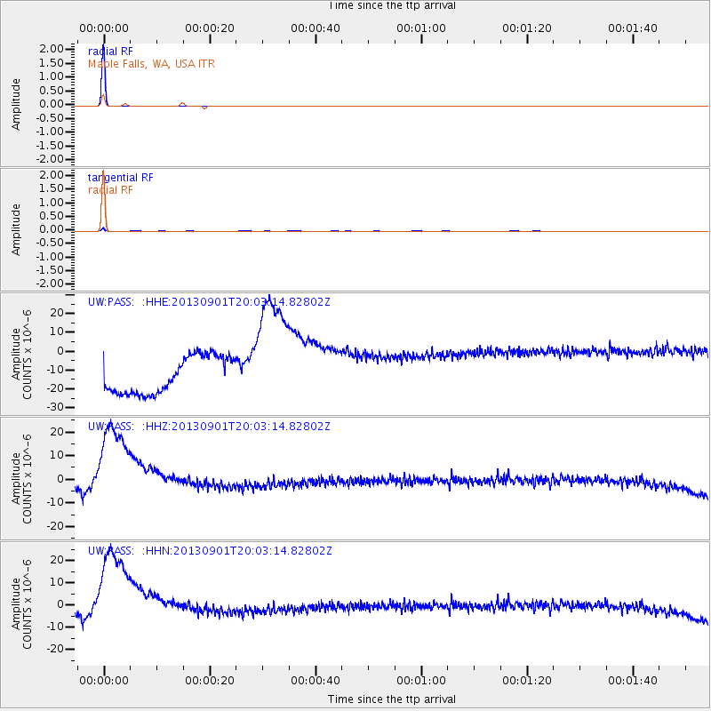
Signal To Noise
| Channel | StoN | STA | LTA |
| UW:PASS: :HHZ:20130901T20:03:14.82802Z | 3.535823 | 2.8402315E-5 | 8.032731E-6 |
| UW:PASS: :HHN:20130901T20:03:14.82802Z | 3.5417182 | 3.042844E-5 | 8.591434E-6 |
| UW:PASS: :HHE:20130901T20:03:14.82802Z | 3.4905574 | 3.3278273E-5 | 9.533799E-6 |
| Arrivals |
| Ps | 8.3 SECOND |
| PpPs | 26 SECOND |
| PsPs/PpSs | 34 SECOND |


