You are here: Home > Network List > AV - Alaska Volcano Observatory Stations List
> Station SPCR Ckakachatna River, Mount Spurr, Alaska > Earthquake Result Viewer
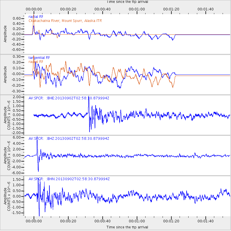
SPCR Ckakachatna River, Mount Spurr, Alaska - Earthquake Result Viewer
*The percent match for this event was below the threshold and hence no stack was calculated.
| Earthquake location: |
Primor'ye, Russia |
| Earthquake latitude/longitude: |
42.2/133.7 |
| Earthquake time(UTC): |
2013/09/02 (245) 02:51:13 GMT |
| Earthquake Depth: |
445 km |
| Earthquake Magnitude: |
5.7 MWW, 5.7 MWW, 5.7 MWB, 5.7 MWC |
| Earthquake Catalog/Contributor: |
NEIC PDE/NEIC COMCAT |
|
| Network: |
AV Alaska Volcano Observatory |
| Station: |
SPCR Ckakachatna River, Mount Spurr, Alaska |
| Lat/Lon: |
61.20 N/152.21 W |
| Elevation: |
984 m |
|
| Distance: |
46.8 deg |
| Az: |
39.677 deg |
| Baz: |
281.563 deg |
| Ray Param: |
$rayparam |
*The percent match for this event was below the threshold and hence was not used in the summary stack. |
|
| Radial Match: |
73.94403 % |
| Radial Bump: |
400 |
| Transverse Match: |
69.88455 % |
| Transverse Bump: |
400 |
| SOD ConfigId: |
626651 |
| Insert Time: |
2014-04-18 07:41:15.975 +0000 |
| GWidth: |
2.5 |
| Max Bumps: |
400 |
| Tol: |
0.001 |
|
Signal To Noise
| Channel | StoN | STA | LTA |
| AV:SPCR: :BHZ:20130902T02:58:30.879994Z | 10.700105 | 2.0106952E-6 | 1.879136E-7 |
| AV:SPCR: :BHN:20130902T02:58:30.879994Z | 3.1528533 | 6.044445E-7 | 1.9171348E-7 |
| AV:SPCR: :BHE:20130902T02:58:30.879994Z | 6.132013 | 7.86599E-7 | 1.2827746E-7 |
| Arrivals |
| Ps | |
| PpPs | |
| PsPs/PpSs | |


