You are here: Home > Network List > IU - Global Seismograph Network (GSN - IRIS/USGS) Stations List
> Station FURI Mt. Furi, Ethiopia > Earthquake Result Viewer
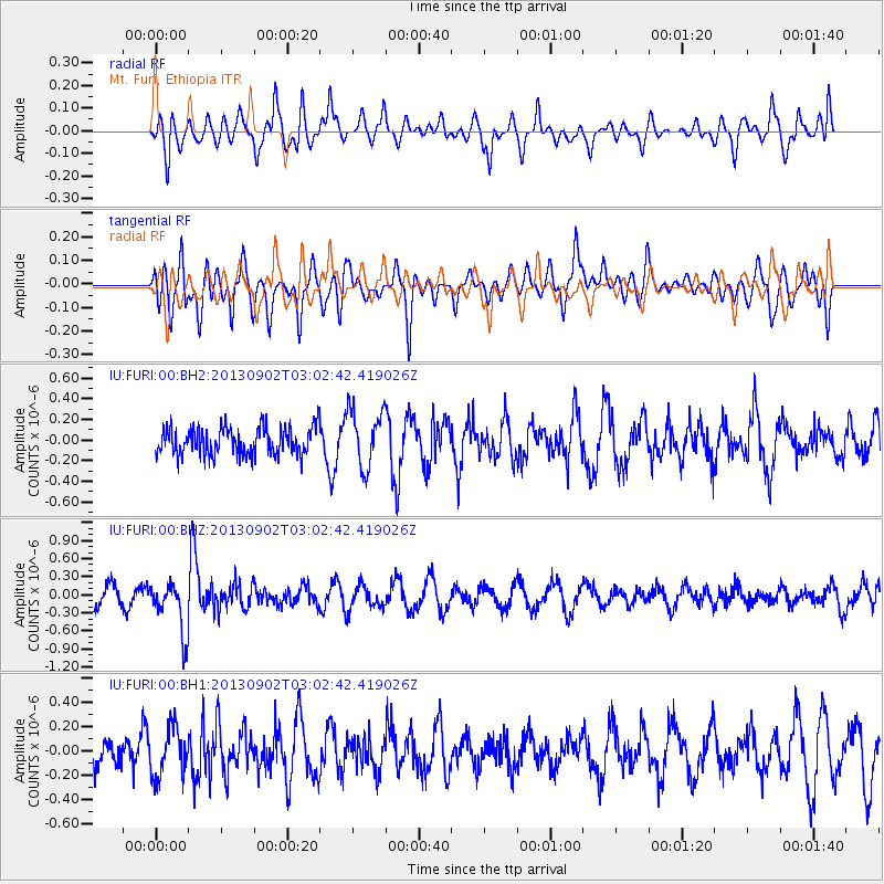
FURI Mt. Furi, Ethiopia - Earthquake Result Viewer
*The percent match for this event was below the threshold and hence no stack was calculated.
| Earthquake location: |
Primor'ye, Russia |
| Earthquake latitude/longitude: |
42.2/133.7 |
| Earthquake time(UTC): |
2013/09/02 (245) 02:51:13 GMT |
| Earthquake Depth: |
445 km |
| Earthquake Magnitude: |
5.7 MWW, 5.7 MWW, 5.7 MWB, 5.7 MWC |
| Earthquake Catalog/Contributor: |
NEIC PDE/NEIC COMCAT |
|
| Network: |
IU Global Seismograph Network (GSN - IRIS/USGS) |
| Station: |
FURI Mt. Furi, Ethiopia |
| Lat/Lon: |
8.90 N/38.68 E |
| Elevation: |
2570 m |
|
| Distance: |
87.8 deg |
| Az: |
279.889 deg |
| Baz: |
47.8 deg |
| Ray Param: |
$rayparam |
*The percent match for this event was below the threshold and hence was not used in the summary stack. |
|
| Radial Match: |
51.925335 % |
| Radial Bump: |
390 |
| Transverse Match: |
60.435623 % |
| Transverse Bump: |
400 |
| SOD ConfigId: |
626651 |
| Insert Time: |
2014-04-18 07:49:21.909 +0000 |
| GWidth: |
2.5 |
| Max Bumps: |
400 |
| Tol: |
0.001 |
|
Signal To Noise
| Channel | StoN | STA | LTA |
| IU:FURI:00:BHZ:20130902T03:02:42.419026Z | 2.3705902 | 4.2491772E-7 | 1.7924553E-7 |
| IU:FURI:00:BH1:20130902T03:02:42.419026Z | 1.2223576 | 2.0081482E-7 | 1.6428484E-7 |
| IU:FURI:00:BH2:20130902T03:02:42.419026Z | 2.108833 | 2.8062695E-7 | 1.3307215E-7 |
| Arrivals |
| Ps | |
| PpPs | |
| PsPs/PpSs | |


