You are here: Home > Network List > II - Global Seismograph Network (GSN - IRIS/IDA) Stations List
> Station ARU Arti, Russia > Earthquake Result Viewer
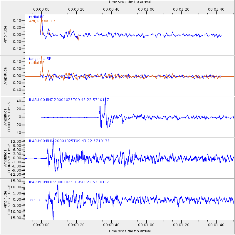
ARU Arti, Russia - Earthquake Result Viewer

| Earthquake location: |
Sunda Strait, Indonesia |
| Earthquake latitude/longitude: |
-6.5/105.6 |
| Earthquake time(UTC): |
2000/10/25 (299) 09:32:23 GMT |
| Earthquake Depth: |
38 km |
| Earthquake Magnitude: |
6.3 MB, 6.6 MS, 6.8 MW, 6.7 ME |
| Earthquake Catalog/Contributor: |
WHDF/NEIC |
|
| Network: |
II Global Seismograph Network (GSN - IRIS/IDA) |
| Station: |
ARU Arti, Russia |
| Lat/Lon: |
56.43 N/58.56 E |
| Elevation: |
250 m |
|
| Distance: |
73.6 deg |
| Az: |
334.918 deg |
| Baz: |
130.698 deg |
| Ray Param: |
0.05281147 |
| Estimated Moho Depth: |
38.25 km |
| Estimated Crust Vp/Vs: |
1.62 |
| Assumed Crust Vp: |
6.159 km/s |
| Estimated Crust Vs: |
3.813 km/s |
| Estimated Crust Poisson's Ratio: |
0.19 |
|
| Radial Match: |
95.988976 % |
| Radial Bump: |
400 |
| Transverse Match: |
93.44349 % |
| Transverse Bump: |
400 |
| SOD ConfigId: |
3744 |
| Insert Time: |
2010-03-01 16:26:07.919 +0000 |
| GWidth: |
2.5 |
| Max Bumps: |
400 |
| Tol: |
0.001 |
|
Signal To Noise
| Channel | StoN | STA | LTA |
| II:ARU:00:BHN:20001025T09:43:22.571013Z | 15.809025 | 2.4502874E-6 | 1.5499295E-7 |
| II:ARU:00:BHE:20001025T09:43:22.571013Z | 21.249372 | 2.4882306E-6 | 1.1709667E-7 |
| II:ARU:00:BHZ:20001025T09:43:22.571013Z | 92.43203 | 1.0375322E-5 | 1.12248124E-7 |
| Arrivals |
| Ps | 4.0 SECOND |
| PpPs | 16 SECOND |
| PsPs/PpSs | 20 SECOND |


