You are here: Home > Network List > TA - USArray Transportable Network (new EarthScope stations) Stations List
> Station H17A Grant Village (NPS), Yellowstone Nt. Park, WY, USA > Earthquake Result Viewer
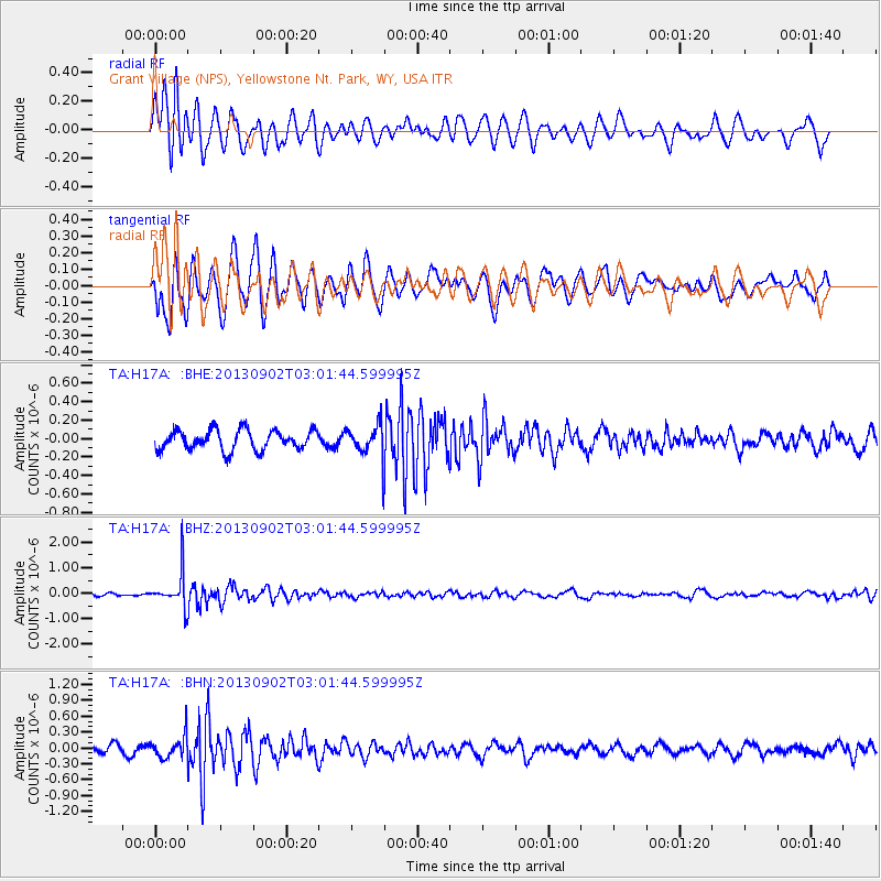
H17A Grant Village (NPS), Yellowstone Nt. Park, WY, USA - Earthquake Result Viewer
*The percent match for this event was below the threshold and hence no stack was calculated.
| Earthquake location: |
Primor'ye, Russia |
| Earthquake latitude/longitude: |
42.2/133.7 |
| Earthquake time(UTC): |
2013/09/02 (245) 02:51:13 GMT |
| Earthquake Depth: |
445 km |
| Earthquake Magnitude: |
5.7 MWW, 5.7 MWW, 5.7 MWB, 5.7 MWC |
| Earthquake Catalog/Contributor: |
NEIC PDE/NEIC COMCAT |
|
| Network: |
TA USArray Transportable Network (new EarthScope stations) |
| Station: |
H17A Grant Village (NPS), Yellowstone Nt. Park, WY, USA |
| Lat/Lon: |
44.40 N/110.58 W |
| Elevation: |
2400 m |
|
| Distance: |
76.4 deg |
| Az: |
41.626 deg |
| Baz: |
316.487 deg |
| Ray Param: |
$rayparam |
*The percent match for this event was below the threshold and hence was not used in the summary stack. |
|
| Radial Match: |
77.682274 % |
| Radial Bump: |
400 |
| Transverse Match: |
52.62353 % |
| Transverse Bump: |
400 |
| SOD ConfigId: |
626651 |
| Insert Time: |
2014-04-18 07:58:35.253 +0000 |
| GWidth: |
2.5 |
| Max Bumps: |
400 |
| Tol: |
0.001 |
|
Signal To Noise
| Channel | StoN | STA | LTA |
| TA:H17A: :BHZ:20130902T03:01:44.599995Z | 11.096431 | 6.8593994E-7 | 6.1816266E-8 |
| TA:H17A: :BHN:20130902T03:01:44.599995Z | 2.732715 | 2.1014934E-7 | 7.690131E-8 |
| TA:H17A: :BHE:20130902T03:01:44.599995Z | 1.5972471 | 1.7014935E-7 | 1.0652663E-7 |
| Arrivals |
| Ps | |
| PpPs | |
| PsPs/PpSs | |


