You are here: Home > Network List > TA - USArray Transportable Network (new EarthScope stations) Stations List
> Station 109C Camp Elliot, Mirimar, CA, USA > Earthquake Result Viewer
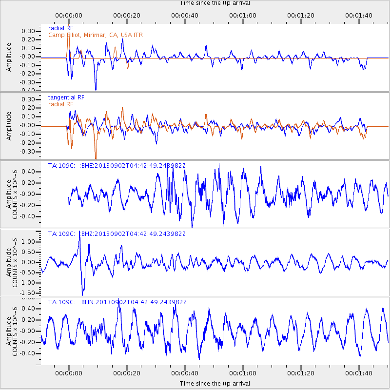
109C Camp Elliot, Mirimar, CA, USA - Earthquake Result Viewer
*The percent match for this event was below the threshold and hence no stack was calculated.
| Earthquake location: |
Solomon Islands |
| Earthquake latitude/longitude: |
-6.6/155.1 |
| Earthquake time(UTC): |
2013/09/02 (245) 04:30:16 GMT |
| Earthquake Depth: |
35 km |
| Earthquake Magnitude: |
5.9 MWW, 5.8 MWB, 6.0 MWC |
| Earthquake Catalog/Contributor: |
NEIC PDE/NEIC COMCAT |
|
| Network: |
TA USArray Transportable Network (new EarthScope stations) |
| Station: |
109C Camp Elliot, Mirimar, CA, USA |
| Lat/Lon: |
32.89 N/117.11 W |
| Elevation: |
150 m |
|
| Distance: |
91.7 deg |
| Az: |
57.256 deg |
| Baz: |
263.252 deg |
| Ray Param: |
$rayparam |
*The percent match for this event was below the threshold and hence was not used in the summary stack. |
|
| Radial Match: |
71.950935 % |
| Radial Bump: |
400 |
| Transverse Match: |
68.739204 % |
| Transverse Bump: |
398 |
| SOD ConfigId: |
626651 |
| Insert Time: |
2014-04-18 08:22:06.785 +0000 |
| GWidth: |
2.5 |
| Max Bumps: |
400 |
| Tol: |
0.001 |
|
Signal To Noise
| Channel | StoN | STA | LTA |
| TA:109C: :BHZ:20130902T04:42:49.243982Z | 2.828362 | 6.104993E-7 | 2.1584907E-7 |
| TA:109C: :BHN:20130902T04:42:49.243982Z | 1.7404515 | 1.7517918E-7 | 1.0065157E-7 |
| TA:109C: :BHE:20130902T04:42:49.243982Z | 1.9910266 | 2.4122605E-7 | 1.2115662E-7 |
| Arrivals |
| Ps | |
| PpPs | |
| PsPs/PpSs | |


