You are here: Home > Network List > TA - USArray Transportable Network (new EarthScope stations) Stations List
> Station J04D Umpqua National Forest, Toketee, OR, USA > Earthquake Result Viewer
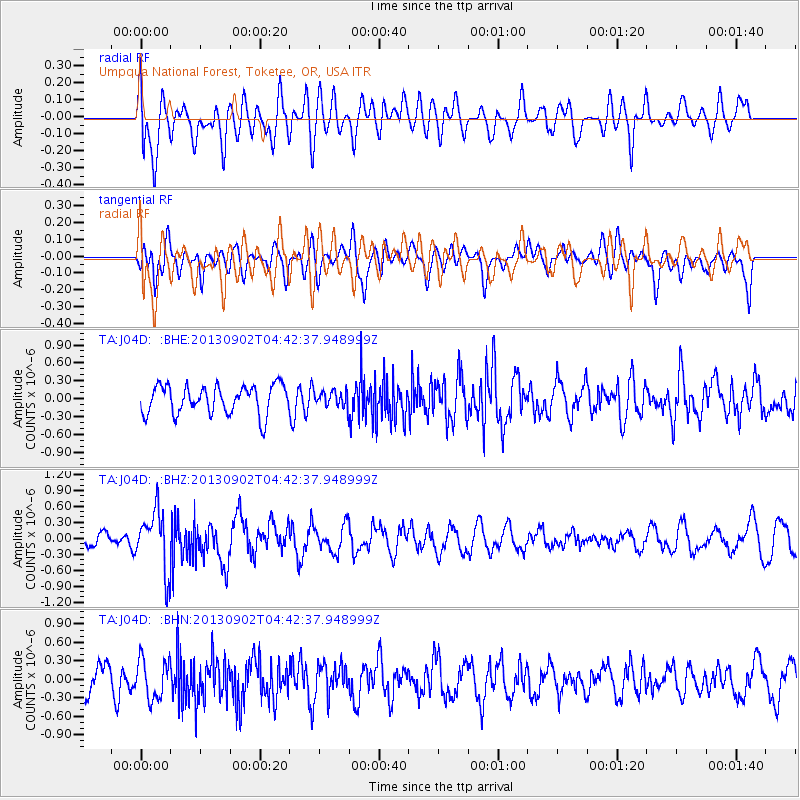
J04D Umpqua National Forest, Toketee, OR, USA - Earthquake Result Viewer
*The percent match for this event was below the threshold and hence no stack was calculated.
| Earthquake location: |
Solomon Islands |
| Earthquake latitude/longitude: |
-6.6/155.1 |
| Earthquake time(UTC): |
2013/09/02 (245) 04:30:16 GMT |
| Earthquake Depth: |
35 km |
| Earthquake Magnitude: |
5.9 MWW, 5.8 MWB, 6.0 MWC |
| Earthquake Catalog/Contributor: |
NEIC PDE/NEIC COMCAT |
|
| Network: |
TA USArray Transportable Network (new EarthScope stations) |
| Station: |
J04D Umpqua National Forest, Toketee, OR, USA |
| Lat/Lon: |
43.24 N/122.11 W |
| Elevation: |
1948 m |
|
| Distance: |
89.2 deg |
| Az: |
46.469 deg |
| Baz: |
260.252 deg |
| Ray Param: |
$rayparam |
*The percent match for this event was below the threshold and hence was not used in the summary stack. |
|
| Radial Match: |
60.57287 % |
| Radial Bump: |
400 |
| Transverse Match: |
48.969986 % |
| Transverse Bump: |
400 |
| SOD ConfigId: |
626651 |
| Insert Time: |
2014-04-18 08:22:44.330 +0000 |
| GWidth: |
2.5 |
| Max Bumps: |
400 |
| Tol: |
0.001 |
|
Signal To Noise
| Channel | StoN | STA | LTA |
| TA:J04D: :BHZ:20130902T04:42:37.948999Z | 3.6376514 | 5.623406E-7 | 1.545889E-7 |
| TA:J04D: :BHN:20130902T04:42:37.948999Z | 1.1240261 | 3.2105035E-7 | 2.8562536E-7 |
| TA:J04D: :BHE:20130902T04:42:37.948999Z | 0.52242875 | 1.2515987E-7 | 2.3957307E-7 |
| Arrivals |
| Ps | |
| PpPs | |
| PsPs/PpSs | |


