You are here: Home > Network List > TA - USArray Transportable Network (new EarthScope stations) Stations List
> Station O03E Paynes Creek, CA, USA > Earthquake Result Viewer
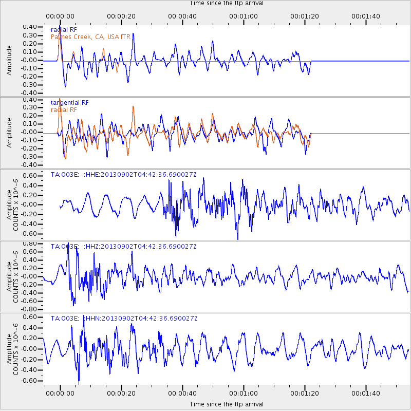
O03E Paynes Creek, CA, USA - Earthquake Result Viewer
*The percent match for this event was below the threshold and hence no stack was calculated.
| Earthquake location: |
Solomon Islands |
| Earthquake latitude/longitude: |
-6.6/155.1 |
| Earthquake time(UTC): |
2013/09/02 (245) 04:30:16 GMT |
| Earthquake Depth: |
35 km |
| Earthquake Magnitude: |
5.9 MWW, 5.8 MWB, 6.0 MWC |
| Earthquake Catalog/Contributor: |
NEIC PDE/NEIC COMCAT |
|
| Network: |
TA USArray Transportable Network (new EarthScope stations) |
| Station: |
O03E Paynes Creek, CA, USA |
| Lat/Lon: |
40.29 N/121.80 W |
| Elevation: |
967 m |
|
| Distance: |
89.0 deg |
| Az: |
49.41 deg |
| Baz: |
260.502 deg |
| Ray Param: |
$rayparam |
*The percent match for this event was below the threshold and hence was not used in the summary stack. |
|
| Radial Match: |
52.92826 % |
| Radial Bump: |
388 |
| Transverse Match: |
65.76214 % |
| Transverse Bump: |
325 |
| SOD ConfigId: |
626651 |
| Insert Time: |
2014-04-18 08:23:03.501 +0000 |
| GWidth: |
2.5 |
| Max Bumps: |
400 |
| Tol: |
0.001 |
|
Signal To Noise
| Channel | StoN | STA | LTA |
| TA:O03E: :HHZ:20130902T04:42:36.690027Z | 4.260923 | 3.8156523E-7 | 8.954991E-8 |
| TA:O03E: :HHN:20130902T04:42:36.690027Z | 1.2327821 | 1.4077283E-7 | 1.1419116E-7 |
| TA:O03E: :HHE:20130902T04:42:36.690027Z | 0.9189205 | 1.3011628E-7 | 1.4159687E-7 |
| Arrivals |
| Ps | |
| PpPs | |
| PsPs/PpSs | |


