You are here: Home > Network List > TA - USArray Transportable Network (new EarthScope stations) Stations List
> Station R11A Troy Canyon, Currant, NV, USA > Earthquake Result Viewer
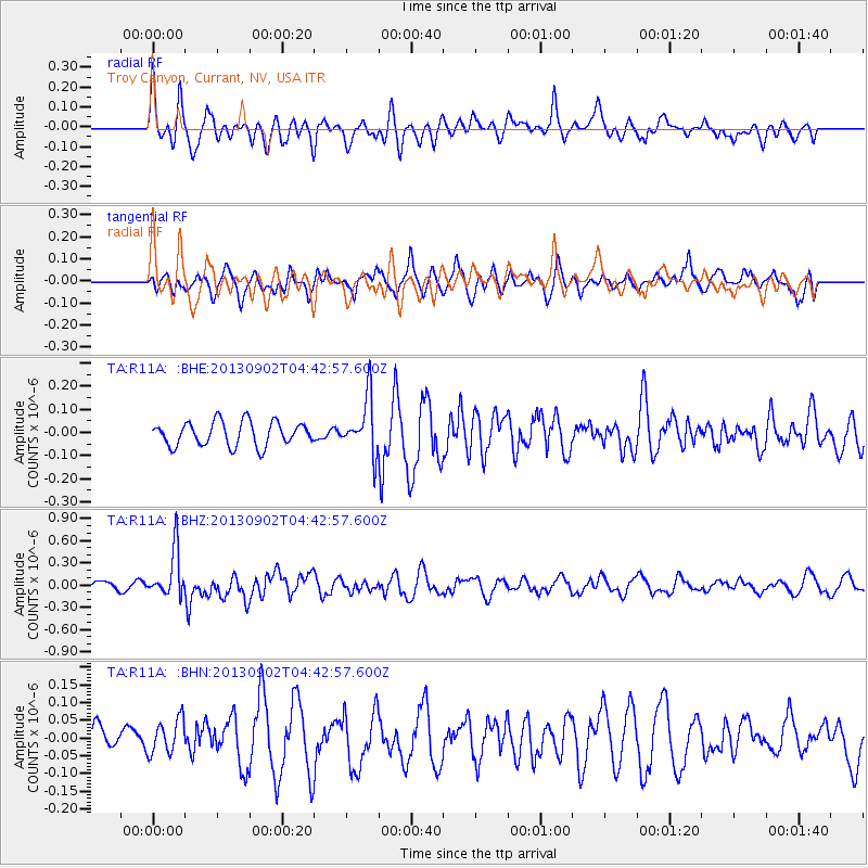
R11A Troy Canyon, Currant, NV, USA - Earthquake Result Viewer
*The percent match for this event was below the threshold and hence no stack was calculated.
| Earthquake location: |
Solomon Islands |
| Earthquake latitude/longitude: |
-6.6/155.1 |
| Earthquake time(UTC): |
2013/09/02 (245) 04:30:16 GMT |
| Earthquake Depth: |
35 km |
| Earthquake Magnitude: |
5.9 MWW, 5.8 MWB, 6.0 MWC |
| Earthquake Catalog/Contributor: |
NEIC PDE/NEIC COMCAT |
|
| Network: |
TA USArray Transportable Network (new EarthScope stations) |
| Station: |
R11A Troy Canyon, Currant, NV, USA |
| Lat/Lon: |
38.35 N/115.59 W |
| Elevation: |
1756 m |
|
| Distance: |
93.5 deg |
| Az: |
51.969 deg |
| Baz: |
264.373 deg |
| Ray Param: |
$rayparam |
*The percent match for this event was below the threshold and hence was not used in the summary stack. |
|
| Radial Match: |
63.356556 % |
| Radial Bump: |
400 |
| Transverse Match: |
58.056038 % |
| Transverse Bump: |
400 |
| SOD ConfigId: |
626651 |
| Insert Time: |
2014-04-18 08:23:08.321 +0000 |
| GWidth: |
2.5 |
| Max Bumps: |
400 |
| Tol: |
0.001 |
|
Signal To Noise
| Channel | StoN | STA | LTA |
| TA:R11A: :BHZ:20130902T04:42:57.600Z | 5.189484 | 3.1621926E-7 | 6.093462E-8 |
| TA:R11A: :BHN:20130902T04:42:57.600Z | 1.0850827 | 4.95183E-8 | 4.5635506E-8 |
| TA:R11A: :BHE:20130902T04:42:57.600Z | 2.3091927 | 1.1922741E-7 | 5.1631638E-8 |
| Arrivals |
| Ps | |
| PpPs | |
| PsPs/PpSs | |


