You are here: Home > Network List > US - United States National Seismic Network Stations List
> Station DUG Dugway, Tooele County, Utah, USA > Earthquake Result Viewer
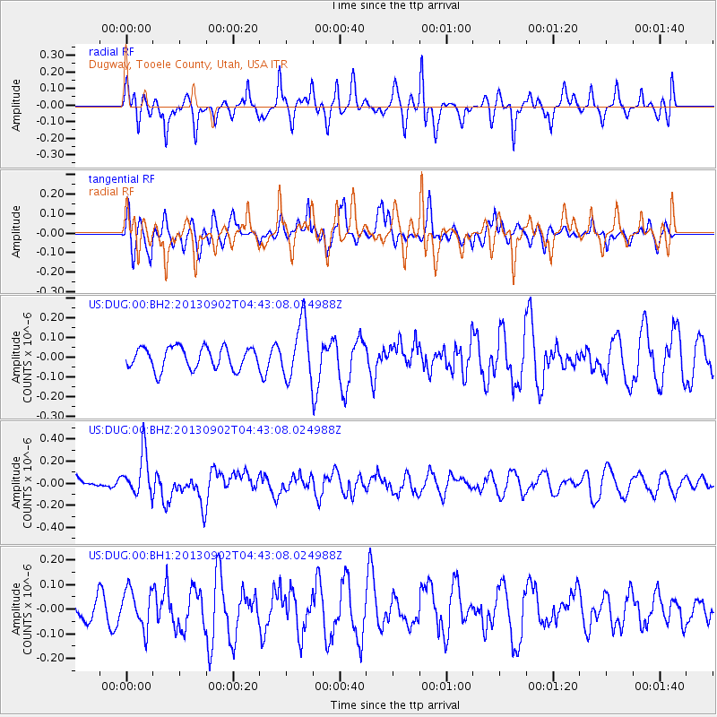
DUG Dugway, Tooele County, Utah, USA - Earthquake Result Viewer
*The percent match for this event was below the threshold and hence no stack was calculated.
| Earthquake location: |
Solomon Islands |
| Earthquake latitude/longitude: |
-6.6/155.1 |
| Earthquake time(UTC): |
2013/09/02 (245) 04:30:16 GMT |
| Earthquake Depth: |
35 km |
| Earthquake Magnitude: |
5.9 MWW, 5.8 MWB, 6.0 MWC |
| Earthquake Catalog/Contributor: |
NEIC PDE/NEIC COMCAT |
|
| Network: |
US United States National Seismic Network |
| Station: |
DUG Dugway, Tooele County, Utah, USA |
| Lat/Lon: |
40.19 N/112.81 W |
| Elevation: |
1477 m |
|
| Distance: |
95.8 deg |
| Az: |
50.302 deg |
| Baz: |
266.257 deg |
| Ray Param: |
$rayparam |
*The percent match for this event was below the threshold and hence was not used in the summary stack. |
|
| Radial Match: |
63.36418 % |
| Radial Bump: |
358 |
| Transverse Match: |
38.6491 % |
| Transverse Bump: |
356 |
| SOD ConfigId: |
626651 |
| Insert Time: |
2014-04-18 08:23:46.175 +0000 |
| GWidth: |
2.5 |
| Max Bumps: |
400 |
| Tol: |
0.001 |
|
Signal To Noise
| Channel | StoN | STA | LTA |
| US:DUG:00:BHZ:20130902T04:43:08.024988Z | 2.2058012 | 1.9340636E-7 | 8.768078E-8 |
| US:DUG:00:BH1:20130902T04:43:08.024988Z | 0.98801494 | 7.954225E-8 | 8.0507135E-8 |
| US:DUG:00:BH2:20130902T04:43:08.024988Z | 2.6206226 | 1.427107E-7 | 5.4456798E-8 |
| Arrivals |
| Ps | |
| PpPs | |
| PsPs/PpSs | |


