You are here: Home > Network List > US - United States National Seismic Network Stations List
> Station HAWA Hanford, Washington, USA > Earthquake Result Viewer
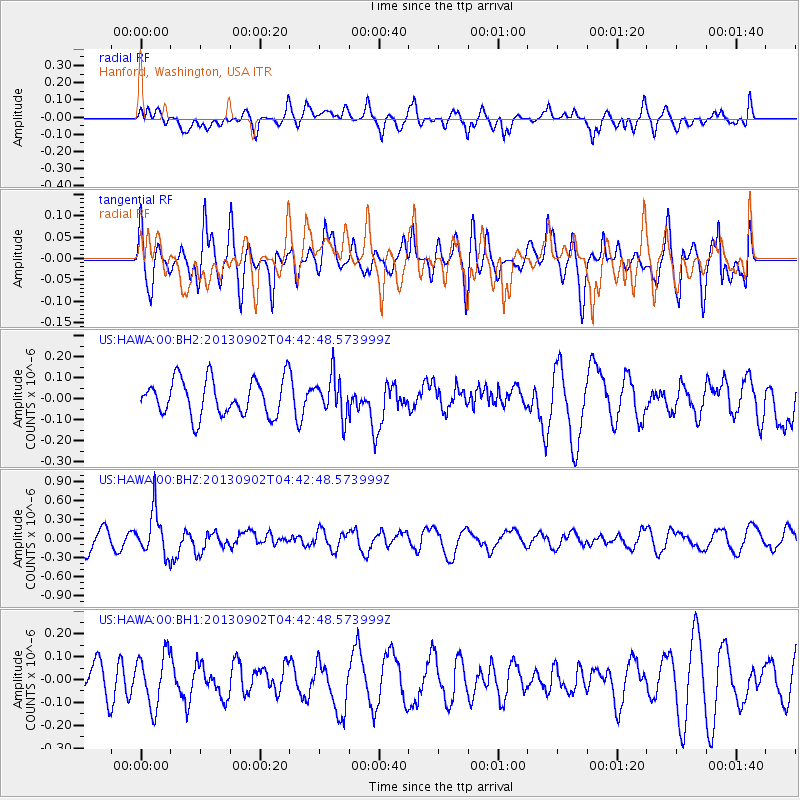
HAWA Hanford, Washington, USA - Earthquake Result Viewer
*The percent match for this event was below the threshold and hence no stack was calculated.
| Earthquake location: |
Solomon Islands |
| Earthquake latitude/longitude: |
-6.6/155.1 |
| Earthquake time(UTC): |
2013/09/02 (245) 04:30:16 GMT |
| Earthquake Depth: |
35 km |
| Earthquake Magnitude: |
5.9 MWW, 5.8 MWB, 6.0 MWC |
| Earthquake Catalog/Contributor: |
NEIC PDE/NEIC COMCAT |
|
| Network: |
US United States National Seismic Network |
| Station: |
HAWA Hanford, Washington, USA |
| Lat/Lon: |
46.39 N/119.53 W |
| Elevation: |
364 m |
|
| Distance: |
91.5 deg |
| Az: |
43.637 deg |
| Baz: |
262.082 deg |
| Ray Param: |
$rayparam |
*The percent match for this event was below the threshold and hence was not used in the summary stack. |
|
| Radial Match: |
60.710117 % |
| Radial Bump: |
400 |
| Transverse Match: |
43.47485 % |
| Transverse Bump: |
400 |
| SOD ConfigId: |
626651 |
| Insert Time: |
2014-04-18 08:23:52.372 +0000 |
| GWidth: |
2.5 |
| Max Bumps: |
400 |
| Tol: |
0.001 |
|
Signal To Noise
| Channel | StoN | STA | LTA |
| US:HAWA:00:BHZ:20130902T04:42:48.573999Z | 2.284538 | 3.4977717E-7 | 1.5310628E-7 |
| US:HAWA:00:BH1:20130902T04:42:48.573999Z | 1.3398391 | 1.15217524E-7 | 8.599355E-8 |
| US:HAWA:00:BH2:20130902T04:42:48.573999Z | 1.0912689 | 9.3951044E-8 | 8.60934E-8 |
| Arrivals |
| Ps | |
| PpPs | |
| PsPs/PpSs | |


