You are here: Home > Network List > WY - Yellowstone Wyoming Seismic Network Stations List
> Station YUF Upper Falls, WY, USA > Earthquake Result Viewer
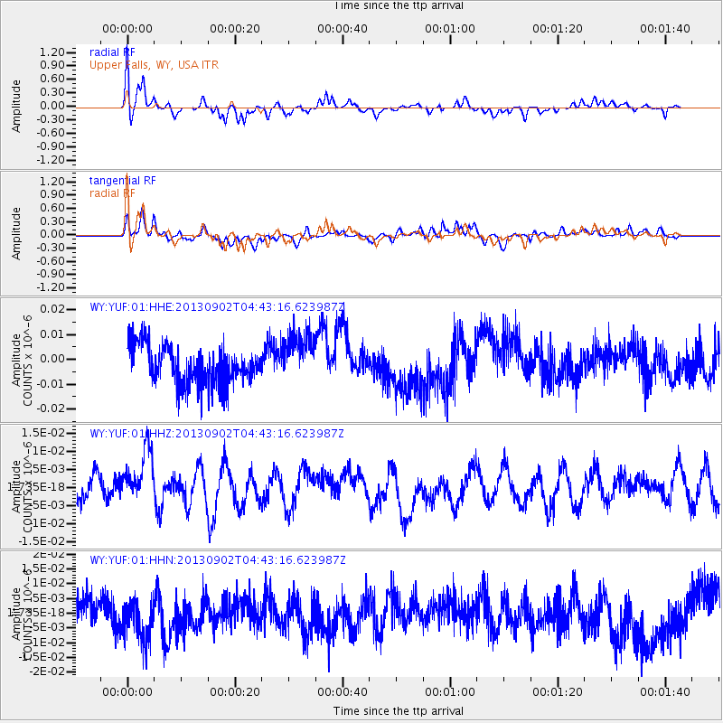
YUF Upper Falls, WY, USA - Earthquake Result Viewer
*The percent match for this event was below the threshold and hence no stack was calculated.
| Earthquake location: |
Solomon Islands |
| Earthquake latitude/longitude: |
-6.6/155.1 |
| Earthquake time(UTC): |
2013/09/02 (245) 04:30:16 GMT |
| Earthquake Depth: |
35 km |
| Earthquake Magnitude: |
5.9 MWW, 5.8 MWB, 6.0 MWC |
| Earthquake Catalog/Contributor: |
NEIC PDE/NEIC COMCAT |
|
| Network: |
WY Yellowstone Wyoming Seismic Network |
| Station: |
YUF Upper Falls, WY, USA |
| Lat/Lon: |
44.71 N/110.51 W |
| Elevation: |
2394 m |
|
| Distance: |
97.7 deg |
| Az: |
45.843 deg |
| Baz: |
268.33 deg |
| Ray Param: |
$rayparam |
*The percent match for this event was below the threshold and hence was not used in the summary stack. |
|
| Radial Match: |
62.587997 % |
| Radial Bump: |
400 |
| Transverse Match: |
66.16122 % |
| Transverse Bump: |
400 |
| SOD ConfigId: |
626651 |
| Insert Time: |
2014-04-18 08:25:57.076 +0000 |
| GWidth: |
2.5 |
| Max Bumps: |
400 |
| Tol: |
0.001 |
|
Signal To Noise
| Channel | StoN | STA | LTA |
| WY:YUF:01:HHZ:20130902T04:43:16.623987Z | 1.7902162 | 8.051896E-9 | 4.4977226E-9 |
| WY:YUF:01:HHN:20130902T04:43:16.623987Z | 1.5728205 | 8.337415E-9 | 5.300932E-9 |
| WY:YUF:01:HHE:20130902T04:43:16.623987Z | 1.3527424 | 1.0444682E-8 | 7.721116E-9 |
| Arrivals |
| Ps | |
| PpPs | |
| PsPs/PpSs | |


