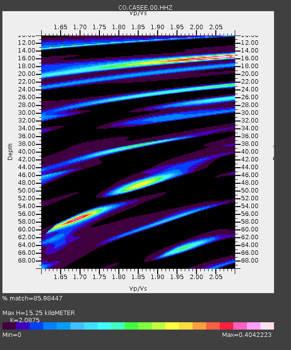
CASEE Lake Jocassee, SC, USA - Earthquake Result Viewer

Earthquake location: Queen Charlotte Islands Region
Earthquake latitude/longitude: 51.2/-130.4
Earthquake time(UTC): 2013/09/03 (246) 20:19:06 GMT
Earthquake Depth: 2.7 km
Earthquake Magnitude: 6.1 MWW, 6.0 MWB, 6.1 MWW, 6.1 MWC, 6.2 MI, 6.2 MWC
Earthquake Catalog/Contributor: NEIC PDE/NEIC COMCAT
Network: CO South Carolina Seismic Network
Station: CASEE Lake Jocassee, SC, USA
Lat/Lon: 34.99 N/82.93 W
Elevation: 385 m
Distance: 37.5 deg
Az: 96.866 deg
Baz: 310.528 deg
Ray Param: 0.07609623
Estimated Moho Depth: 15.25 km
Estimated Crust Vp/Vs: 2.09
Assumed Crust Vp: 6.35 km/s
Estimated Crust Vs: 3.042 km/s
Estimated Crust Poisson's Ratio: 0.35
Radial Match: 85.98447 %
Radial Bump: 305
Transverse Match: 53.148327 %
Transverse Bump: 400
SOD ConfigId: 626651
Insert Time: 2014-04-18 08:28:40.185 +0000
GWidth: 2.5
Max Bumps: 400
Tol: 0.001

Signal To Noise

ChannelStoNSTALTA
CO:CASEE:00:HHZ:20130903T20:25:50.847996Z5.6140265.9960416E-71.0680466E-7
CO:CASEE:00:HHN:20130903T20:25:50.847996Z2.91902382.379789E-78.1526885E-8
CO:CASEE:00:HHE:20130903T20:25:50.847996Z2.12628633.4226386E-71.609679E-7
Arrivals
Ps2.8 SECOND
PpPs7.0 SECOND
PsPs/PpSs9.8 SECOND