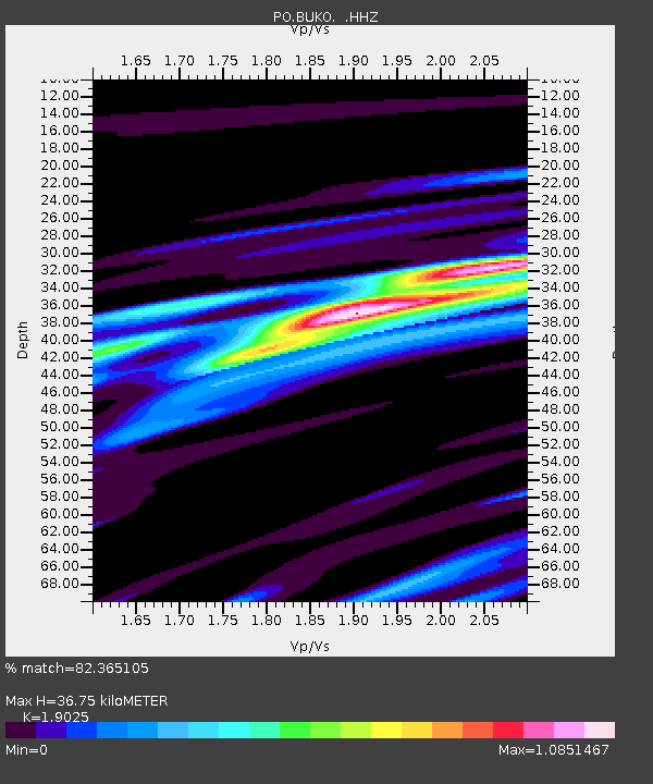
BUKO BUCK LAKE, ON - Earthquake Result Viewer

Earthquake location: Queen Charlotte Islands Region
Earthquake latitude/longitude: 51.2/-130.4
Earthquake time(UTC): 2013/09/03 (246) 20:19:06 GMT
Earthquake Depth: 2.7 km
Earthquake Magnitude: 6.1 MWW, 6.0 MWB, 6.1 MWW, 6.1 MWC, 6.2 MI, 6.2 MWC
Earthquake Catalog/Contributor: NEIC PDE/NEIC COMCAT
Network: PO Portable Observatories for Lithospheric Analysis and Research Investigating Seis
Station: BUKO BUCK LAKE, ON
Lat/Lon: 45.44 N/79.40 W
Elevation: 317 m
Distance: 33.8 deg
Az: 79.46 deg
Baz: 298.627 deg
Ray Param: 0.078049816
Estimated Moho Depth: 36.75 km
Estimated Crust Vp/Vs: 1.90
Assumed Crust Vp: 6.577 km/s
Estimated Crust Vs: 3.457 km/s
Estimated Crust Poisson's Ratio: 0.31
Radial Match: 82.365105 %
Radial Bump: 396
Transverse Match: 39.038433 %
Transverse Bump: 400
SOD ConfigId: 626651
Insert Time: 2014-04-18 08:36:34.600 +0000
GWidth: 2.5
Max Bumps: 400
Tol: 0.001

Signal To Noise

ChannelStoNSTALTA
PO:BUKO: :HHZ:20130903T20:25:18.910007Z3.76582722.4481955E-76.501082E-8
PO:BUKO: :HHN:20130903T20:25:18.910007Z1.66956091.051838E-76.3000876E-8
PO:BUKO: :HHE:20130903T20:25:18.910007Z2.8683721.3518223E-74.712856E-8
Arrivals
Ps5.4 SECOND
PpPs15 SECOND
PsPs/PpSs20 SECOND