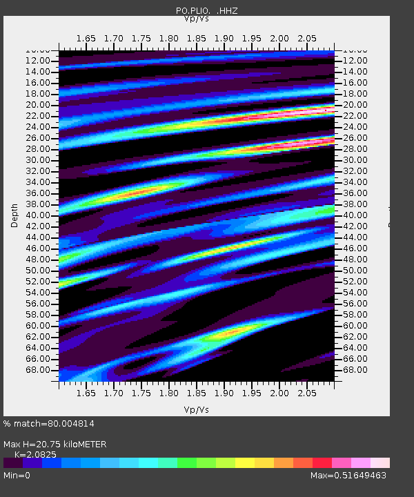
PLIO PELEE ISLAND, ON - Earthquake Result Viewer

Earthquake location: Queen Charlotte Islands Region
Earthquake latitude/longitude: 51.2/-130.4
Earthquake time(UTC): 2013/09/03 (246) 20:19:06 GMT
Earthquake Depth: 2.7 km
Earthquake Magnitude: 6.1 MWW, 6.0 MWB, 6.1 MWW, 6.1 MWC, 6.2 MI, 6.2 MWC
Earthquake Catalog/Contributor: NEIC PDE/NEIC COMCAT
Network: PO Portable Observatories for Lithospheric Analysis and Research Investigating Seis
Station: PLIO PELEE ISLAND, ON
Lat/Lon: 41.75 N/82.63 W
Elevation: 143 m
Distance: 33.7 deg
Az: 87.331 deg
Baz: 302.954 deg
Ray Param: 0.07810855
Estimated Moho Depth: 20.75 km
Estimated Crust Vp/Vs: 2.08
Assumed Crust Vp: 6.498 km/s
Estimated Crust Vs: 3.12 km/s
Estimated Crust Poisson's Ratio: 0.35
Radial Match: 80.004814 %
Radial Bump: 339
Transverse Match: 58.96611 %
Transverse Bump: 400
SOD ConfigId: 626651
Insert Time: 2014-04-18 08:37:08.777 +0000
GWidth: 2.5
Max Bumps: 400
Tol: 0.001

Signal To Noise

ChannelStoNSTALTA
PO:PLIO: :HHZ:20130903T20:25:17.799991Z2.9224091.5878042E-75.4332034E-8
PO:PLIO: :HHN:20130903T20:25:17.799991Z1.89833828.204921E-84.3221597E-8
PO:PLIO: :HHE:20130903T20:25:17.799991Z2.21254441.1656261E-75.268261E-8
Arrivals
Ps3.7 SECOND
PpPs9.2 SECOND
PsPs/PpSs13 SECOND