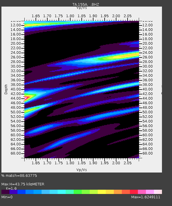
155A Kite, GA, USA - Earthquake Result Viewer
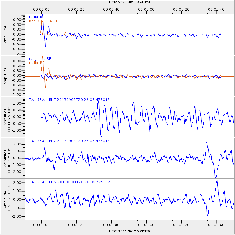
Earthquake location: Queen Charlotte Islands Region
Earthquake latitude/longitude: 51.2/-130.4
Earthquake time(UTC): 2013/09/03 (246) 20:19:06 GMT
Earthquake Depth: 2.7 km
Earthquake Magnitude: 6.1 MWW, 6.0 MWB, 6.1 MWW, 6.1 MWC, 6.2 MI, 6.2 MWC
Earthquake Catalog/Contributor: NEIC PDE/NEIC COMCAT
Network: TA USArray Transportable Network (new EarthScope stations)
Station: 155A Kite, GA, USA
Lat/Lon: 32.62 N/82.47 W
Elevation: 93 m
Distance: 39.4 deg
Az: 99.295 deg
Baz: 312.688 deg
Ray Param: 0.07502251
Estimated Moho Depth: 43.75 km
Estimated Crust Vp/Vs: 1.60
Assumed Crust Vp: 6.565 km/s
Estimated Crust Vs: 4.103 km/s
Estimated Crust Poisson's Ratio: 0.18
Radial Match: 88.63775 %
Radial Bump: 322
Transverse Match: 52.802498 %
Transverse Bump: 400
SOD ConfigId: 626651
Insert Time: 2014-04-18 08:38:23.449 +0000
GWidth: 2.5
Max Bumps: 400
Tol: 0.001

Signal To Noise

ChannelStoNSTALTA
TA:155A: :BHZ:20130903T20:26:06.47501Z5.1679465.15854E-79.9817996E-8
TA:155A: :BHN:20130903T20:26:06.47501Z2.5165873.5666528E-71.4172578E-7
TA:155A: :BHE:20130903T20:26:06.47501Z3.34616787.665346E-72.2907835E-7
Arrivals
Ps4.3 SECOND
PpPs16 SECOND
PsPs/PpSs20 SECOND