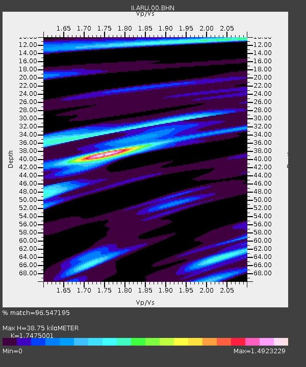
ARU Arti, Russia - Earthquake Result Viewer
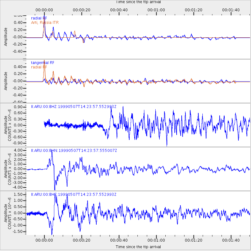
Earthquake location: Kodiak Island Region, Alaska
Earthquake latitude/longitude: 56.4/-152.9
Earthquake time(UTC): 1999/05/07 (127) 14:13:52 GMT
Earthquake Depth: 20 km
Earthquake Magnitude: 5.7 MB, 6.1 MS, 6.4 MW, 5.7 ME
Earthquake Catalog/Contributor: WHDF/NEIC
Network: II Global Seismograph Network (GSN - IRIS/IDA)
Station: ARU Arti, Russia
Lat/Lon: 56.43 N/58.56 E
Elevation: 250 m
Distance: 64.7 deg
Az: 341.265 deg
Baz: 18.742 deg
Ray Param: 0.058760863
Estimated Moho Depth: 38.75 km
Estimated Crust Vp/Vs: 1.75
Assumed Crust Vp: 6.159 km/s
Estimated Crust Vs: 3.524 km/s
Estimated Crust Poisson's Ratio: 0.26
Radial Match: 96.547195 %
Radial Bump: 392
Transverse Match: 84.774574 %
Transverse Bump: 400
SOD ConfigId: 4480
Insert Time: 2010-03-01 16:27:56.458 +0000
GWidth: 2.5
Max Bumps: 400
Tol: 0.001

Signal To Noise

ChannelStoNSTALTA
II:ARU:00:BHN:19990507T14:23:57.555007Z27.1650521.508353E-65.5525497E-8
II:ARU:00:BHE:19990507T14:23:57.552993Z10.03935056.969988E-76.942668E-8
II:ARU:00:BHZ:19990507T14:23:57.552993Z3.53612452.857546E-78.081011E-8
Arrivals
Ps4.9 SECOND
PpPs17 SECOND
PsPs/PpSs22 SECOND