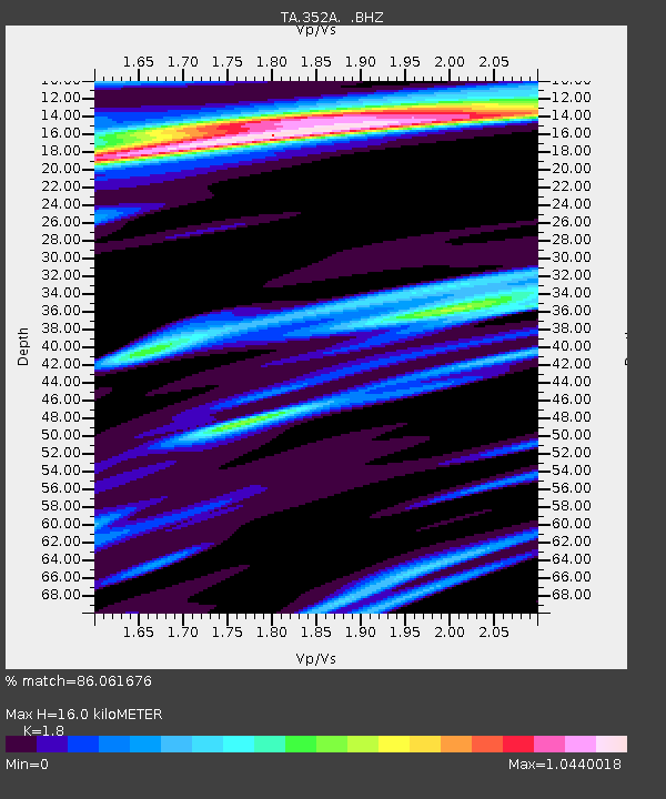
352A Blakely, GA, USA - Earthquake Result Viewer

Earthquake location: Queen Charlotte Islands Region
Earthquake latitude/longitude: 51.2/-130.4
Earthquake time(UTC): 2013/09/03 (246) 20:19:06 GMT
Earthquake Depth: 2.7 km
Earthquake Magnitude: 6.1 MWW, 6.0 MWB, 6.1 MWW, 6.1 MWC, 6.2 MI, 6.2 MWC
Earthquake Catalog/Contributor: NEIC PDE/NEIC COMCAT
Network: TA USArray Transportable Network (new EarthScope stations)
Station: 352A Blakely, GA, USA
Lat/Lon: 31.48 N/84.93 W
Elevation: 101 m
Distance: 38.7 deg
Az: 102.89 deg
Baz: 314.18 deg
Ray Param: 0.07544701
Estimated Moho Depth: 16.0 km
Estimated Crust Vp/Vs: 1.80
Assumed Crust Vp: 6.347 km/s
Estimated Crust Vs: 3.526 km/s
Estimated Crust Poisson's Ratio: 0.28
Radial Match: 86.061676 %
Radial Bump: 332
Transverse Match: 50.42003 %
Transverse Bump: 400
SOD ConfigId: 626651
Insert Time: 2014-04-18 08:38:48.660 +0000
GWidth: 2.5
Max Bumps: 400
Tol: 0.001

Signal To Noise

ChannelStoNSTALTA
TA:352A: :BHZ:20130903T20:26:00.35001Z5.4125059.711149E-71.794206E-7
TA:352A: :BHN:20130903T20:26:00.35001Z1.41780955.260165E-73.7100645E-7
TA:352A: :BHE:20130903T20:26:00.35001Z1.131044.1479177E-73.6673484E-7
Arrivals
Ps2.2 SECOND
PpPs6.6 SECOND
PsPs/PpSs8.7 SECOND