You are here: Home > Network List > TA - USArray Transportable Network (new EarthScope stations) Stations List
> Station 357A Townsend, GA, USA > Earthquake Result Viewer
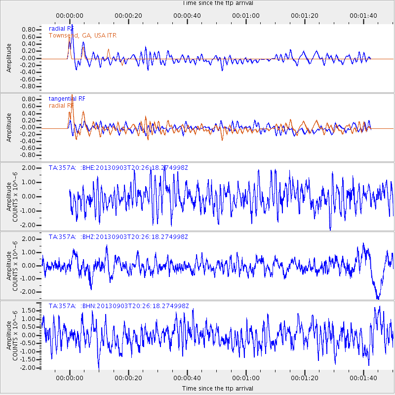
357A Townsend, GA, USA - Earthquake Result Viewer
*The percent match for this event was below the threshold and hence no stack was calculated.
| Earthquake location: |
Queen Charlotte Islands Region |
| Earthquake latitude/longitude: |
51.2/-130.4 |
| Earthquake time(UTC): |
2013/09/03 (246) 20:19:06 GMT |
| Earthquake Depth: |
2.7 km |
| Earthquake Magnitude: |
6.1 MWW, 6.0 MWB, 6.1 MWW, 6.1 MWC, 6.2 MI, 6.2 MWC |
| Earthquake Catalog/Contributor: |
NEIC PDE/NEIC COMCAT |
|
| Network: |
TA USArray Transportable Network (new EarthScope stations) |
| Station: |
357A Townsend, GA, USA |
| Lat/Lon: |
31.42 N/81.49 W |
| Elevation: |
7.0 m |
|
| Distance: |
40.8 deg |
| Az: |
99.764 deg |
| Baz: |
313.564 deg |
| Ray Param: |
$rayparam |
*The percent match for this event was below the threshold and hence was not used in the summary stack. |
|
| Radial Match: |
72.41024 % |
| Radial Bump: |
400 |
| Transverse Match: |
47.408653 % |
| Transverse Bump: |
400 |
| SOD ConfigId: |
626651 |
| Insert Time: |
2014-04-18 08:38:58.728 +0000 |
| GWidth: |
2.5 |
| Max Bumps: |
400 |
| Tol: |
0.001 |
|
Signal To Noise
| Channel | StoN | STA | LTA |
| TA:357A: :BHZ:20130903T20:26:18.274998Z | 2.0591094 | 6.2005455E-7 | 3.0112753E-7 |
| TA:357A: :BHN:20130903T20:26:18.274998Z | 0.89433753 | 4.8816617E-7 | 5.458411E-7 |
| TA:357A: :BHE:20130903T20:26:18.274998Z | 1.7661654 | 1.1701935E-6 | 6.625617E-7 |
| Arrivals |
| Ps | |
| PpPs | |
| PsPs/PpSs | |


