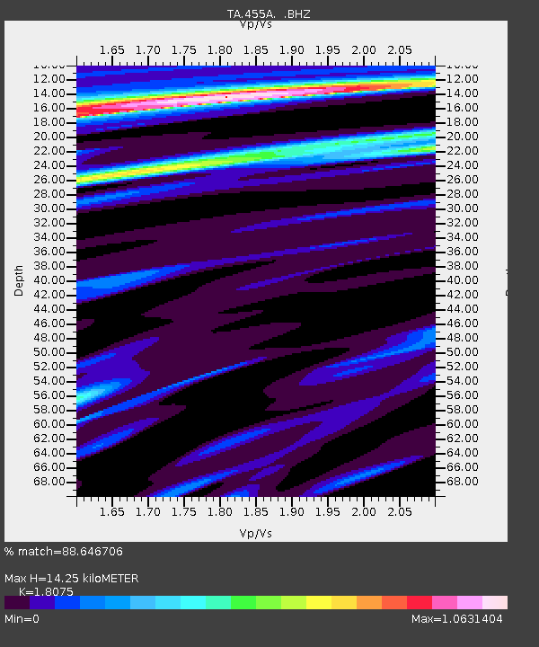
455A Stateville, GA, USA - Earthquake Result Viewer

Earthquake location: Queen Charlotte Islands Region
Earthquake latitude/longitude: 51.2/-130.4
Earthquake time(UTC): 2013/09/03 (246) 20:19:06 GMT
Earthquake Depth: 2.7 km
Earthquake Magnitude: 6.1 MWW, 6.0 MWB, 6.1 MWW, 6.1 MWC, 6.2 MI, 6.2 MWC
Earthquake Catalog/Contributor: NEIC PDE/NEIC COMCAT
Network: TA USArray Transportable Network (new EarthScope stations)
Station: 455A Stateville, GA, USA
Lat/Lon: 30.74 N/83.03 W
Elevation: 44 m
Distance: 40.3 deg
Az: 101.926 deg
Baz: 314.415 deg
Ray Param: 0.07446717
Estimated Moho Depth: 14.25 km
Estimated Crust Vp/Vs: 1.81
Assumed Crust Vp: 6.565 km/s
Estimated Crust Vs: 3.632 km/s
Estimated Crust Poisson's Ratio: 0.28
Radial Match: 88.646706 %
Radial Bump: 371
Transverse Match: 68.135635 %
Transverse Bump: 400
SOD ConfigId: 626651
Insert Time: 2014-04-18 08:39:10.323 +0000
GWidth: 2.5
Max Bumps: 400
Tol: 0.001

Signal To Noise

ChannelStoNSTALTA
TA:455A: :BHZ:20130903T20:26:14.324009Z3.17677335.550297E-71.7471491E-7
TA:455A: :BHN:20130903T20:26:14.324009Z2.5873883.8216365E-71.4770248E-7
TA:455A: :BHE:20130903T20:26:14.324009Z1.54835983.1966135E-72.0645162E-7
Arrivals
Ps1.9 SECOND
PpPs5.7 SECOND
PsPs/PpSs7.6 SECOND