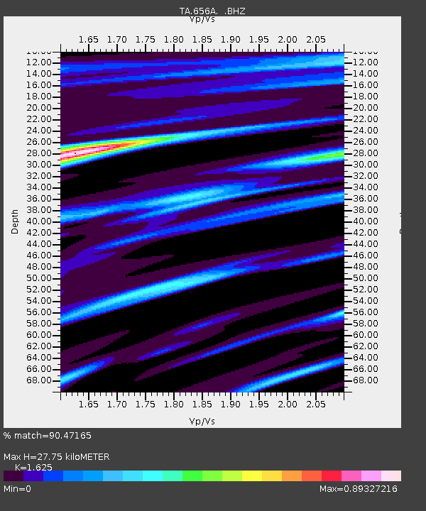
656A Willston, FL, USA - Earthquake Result Viewer

Earthquake location: Queen Charlotte Islands Region
Earthquake latitude/longitude: 51.2/-130.4
Earthquake time(UTC): 2013/09/03 (246) 20:19:06 GMT
Earthquake Depth: 2.7 km
Earthquake Magnitude: 6.1 MWW, 6.0 MWB, 6.1 MWW, 6.1 MWC, 6.2 MI, 6.2 MWC
Earthquake Catalog/Contributor: NEIC PDE/NEIC COMCAT
Network: TA USArray Transportable Network (new EarthScope stations)
Station: 656A Willston, FL, USA
Lat/Lon: 29.37 N/82.53 W
Elevation: 28 m
Distance: 41.6 deg
Az: 102.945 deg
Baz: 315.429 deg
Ray Param: 0.07369879
Estimated Moho Depth: 27.75 km
Estimated Crust Vp/Vs: 1.62
Assumed Crust Vp: 5.989 km/s
Estimated Crust Vs: 3.686 km/s
Estimated Crust Poisson's Ratio: 0.20
Radial Match: 90.47165 %
Radial Bump: 381
Transverse Match: 51.124756 %
Transverse Bump: 400
SOD ConfigId: 626651
Insert Time: 2014-04-18 08:39:19.197 +0000
GWidth: 2.5
Max Bumps: 400
Tol: 0.001

Signal To Noise

ChannelStoNSTALTA
TA:656A: :BHZ:20130903T20:26:24.774998Z6.23816877.078521E-71.1347114E-7
TA:656A: :BHN:20130903T20:26:24.774998Z1.51265842.770746E-71.8317064E-7
TA:656A: :BHE:20130903T20:26:24.774998Z2.0548293.4862842E-71.69663E-7
Arrivals
Ps3.1 SECOND
PpPs11 SECOND
PsPs/PpSs14 SECOND