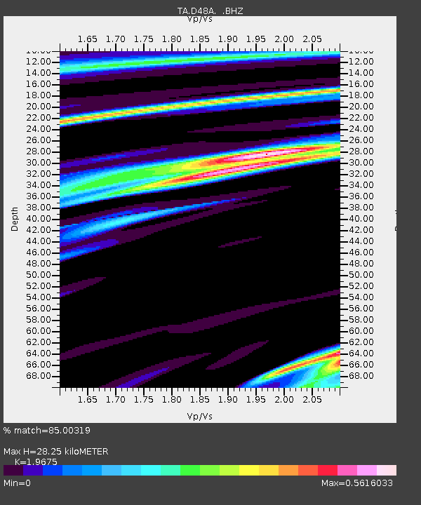
D48A Paudash Township, ON, CAN - Earthquake Result Viewer

Earthquake location: Queen Charlotte Islands Region
Earthquake latitude/longitude: 51.2/-130.4
Earthquake time(UTC): 2013/09/03 (246) 20:19:06 GMT
Earthquake Depth: 2.7 km
Earthquake Magnitude: 6.1 MWW, 6.0 MWB, 6.1 MWW, 6.1 MWC, 6.2 MI, 6.2 MWC
Earthquake Catalog/Contributor: NEIC PDE/NEIC COMCAT
Network: TA USArray Transportable Network (new EarthScope stations)
Station: D48A Paudash Township, ON, CAN
Lat/Lon: 47.17 N/81.81 W
Elevation: 434 m
Distance: 31.5 deg
Az: 78.017 deg
Baz: 295.675 deg
Ray Param: 0.079048954
Estimated Moho Depth: 28.25 km
Estimated Crust Vp/Vs: 1.97
Assumed Crust Vp: 6.467 km/s
Estimated Crust Vs: 3.287 km/s
Estimated Crust Poisson's Ratio: 0.33
Radial Match: 85.00319 %
Radial Bump: 400
Transverse Match: 55.967106 %
Transverse Bump: 400
SOD ConfigId: 626651
Insert Time: 2014-04-18 08:39:31.339 +0000
GWidth: 2.5
Max Bumps: 400
Tol: 0.001

Signal To Noise

ChannelStoNSTALTA
TA:D48A: :BHZ:20130903T20:24:59.049991Z1.49389163.4893026E-72.3357134E-7
TA:D48A: :BHN:20130903T20:24:59.049991Z0.805367651.5016329E-71.864531E-7
TA:D48A: :BHE:20130903T20:24:59.049991Z2.92760233.9450836E-71.3475477E-7
Arrivals
Ps4.5 SECOND
PpPs12 SECOND
PsPs/PpSs17 SECOND