You are here: Home > Network List > TA - USArray Transportable Network (new EarthScope stations) Stations List
> Station D53A Lac Vacive, Pontiac, Mrc, QC, CAN > Earthquake Result Viewer
D53A Lac Vacive, Pontiac, Mrc, QC, CAN - Earthquake Result Viewer
| Earthquake location: |
Queen Charlotte Islands Region |
| Earthquake latitude/longitude: |
51.2/-130.4 |
| Earthquake time(UTC): |
2013/09/03 (246) 20:19:06 GMT |
| Earthquake Depth: |
2.7 km |
| Earthquake Magnitude: |
6.1 MWW, 6.0 MWB, 6.1 MWW, 6.1 MWC, 6.2 MI, 6.2 MWC |
| Earthquake Catalog/Contributor: |
NEIC PDE/NEIC COMCAT |
|
| Network: |
TA USArray Transportable Network (new EarthScope stations) |
| Station: |
D53A Lac Vacive, Pontiac, Mrc, QC, CAN |
| Lat/Lon: |
47.08 N/77.70 W |
| Elevation: |
347 m |
|
| Distance: |
34.1 deg |
| Az: |
75.883 deg |
| Baz: |
296.883 deg |
| Ray Param: |
0.077920586 |
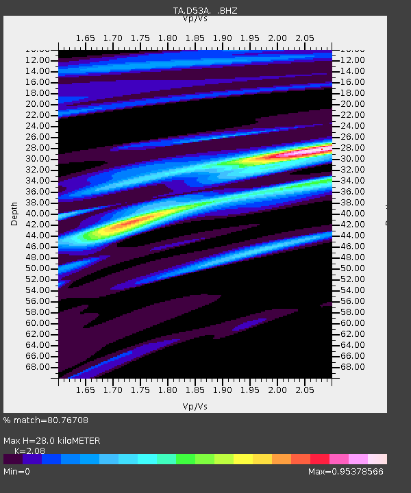
| Estimated Moho Depth: |
28.0 km |
| Estimated Crust Vp/Vs: |
2.08 |
| Assumed Crust Vp: |
6.622 km/s |
| Estimated Crust Vs: |
3.184 km/s |
| Estimated Crust Poisson's Ratio: |
0.35 |
|
| Radial Match: |
80.76708 % |
| Radial Bump: |
400 |
| Transverse Match: |
63.988617 % |
| Transverse Bump: |
400 |
| SOD ConfigId: |
626651 |
| Insert Time: |
2014-04-18 08:39:40.236 +0000 |
| GWidth: |
2.5 |
| Max Bumps: |
400 |
| Tol: |
0.001 |
|

Signal To Noise
| Channel | StoN | STA | LTA |
| TA:D53A: :BHZ:20130903T20:25:21.35001Z | 3.442905 | 5.1071726E-7 | 1.4833905E-7 |
| TA:D53A: :BHN:20130903T20:25:21.35001Z | 1.1525052 | 1.4195247E-7 | 1.2316862E-7 |
| TA:D53A: :BHE:20130903T20:25:21.35001Z | 1.964554 | 3.486086E-7 | 1.7744924E-7 |
| Arrivals |
| Ps | 4.9 SECOND |
| PpPs | 12 SECOND |
| PsPs/PpSs | 17 SECOND |


