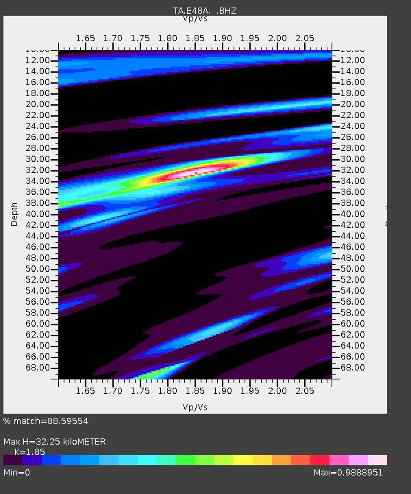
E48A Lockeyer, ON, CAN - Earthquake Result Viewer
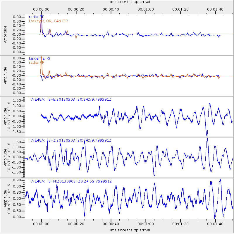
Earthquake location: Queen Charlotte Islands Region
Earthquake latitude/longitude: 51.2/-130.4
Earthquake time(UTC): 2013/09/03 (246) 20:19:06 GMT
Earthquake Depth: 2.7 km
Earthquake Magnitude: 6.1 MWW, 6.0 MWB, 6.1 MWW, 6.1 MWC, 6.2 MI, 6.2 MWC
Earthquake Catalog/Contributor: NEIC PDE/NEIC COMCAT
Network: TA USArray Transportable Network (new EarthScope stations)
Station: E48A Lockeyer, ON, CAN
Lat/Lon: 46.48 N/82.17 W
Elevation: 347 m
Distance: 31.6 deg
Az: 79.413 deg
Baz: 296.604 deg
Ray Param: 0.07901285
Estimated Moho Depth: 32.25 km
Estimated Crust Vp/Vs: 1.85
Assumed Crust Vp: 6.467 km/s
Estimated Crust Vs: 3.495 km/s
Estimated Crust Poisson's Ratio: 0.29
Radial Match: 88.59554 %
Radial Bump: 275
Transverse Match: 56.07527 %
Transverse Bump: 400
SOD ConfigId: 626651
Insert Time: 2014-04-18 08:39:55.780 +0000
GWidth: 2.5
Max Bumps: 400
Tol: 0.001

Signal To Noise

ChannelStoNSTALTA
TA:E48A: :BHZ:20130903T20:24:59.799991Z3.78788615.496241E-71.4510047E-7
TA:E48A: :BHN:20130903T20:24:59.799991Z1.43364232.7481624E-71.9169096E-7
TA:E48A: :BHE:20130903T20:24:59.799991Z2.1382913.6741275E-71.7182543E-7
Arrivals
Ps4.6 SECOND
PpPs13 SECOND
PsPs/PpSs18 SECOND