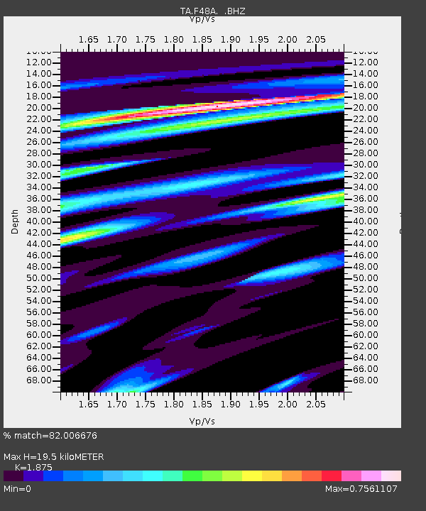
F48A Evansville, ON, CAN - Earthquake Result Viewer
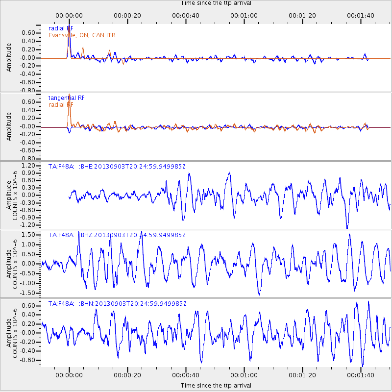
Earthquake location: Queen Charlotte Islands Region
Earthquake latitude/longitude: 51.2/-130.4
Earthquake time(UTC): 2013/09/03 (246) 20:19:06 GMT
Earthquake Depth: 2.7 km
Earthquake Magnitude: 6.1 MWW, 6.0 MWB, 6.1 MWW, 6.1 MWC, 6.2 MI, 6.2 MWC
Earthquake Catalog/Contributor: NEIC PDE/NEIC COMCAT
Network: TA USArray Transportable Network (new EarthScope stations)
Station: F48A Evansville, ON, CAN
Lat/Lon: 45.83 N/82.62 W
Elevation: 203 m
Distance: 31.6 deg
Az: 80.795 deg
Baz: 297.456 deg
Ray Param: 0.07900594
Estimated Moho Depth: 19.5 km
Estimated Crust Vp/Vs: 1.88
Assumed Crust Vp: 6.483 km/s
Estimated Crust Vs: 3.457 km/s
Estimated Crust Poisson's Ratio: 0.30
Radial Match: 82.006676 %
Radial Bump: 400
Transverse Match: 54.91205 %
Transverse Bump: 400
SOD ConfigId: 626651
Insert Time: 2014-04-18 08:40:12.574 +0000
GWidth: 2.5
Max Bumps: 400
Tol: 0.001

Signal To Noise

ChannelStoNSTALTA
TA:F48A: :BHZ:20130903T20:24:59.949985Z2.44472655.379325E-72.2003792E-7
TA:F48A: :BHN:20130903T20:24:59.949985Z0.93966941.2782324E-71.3603002E-7
TA:F48A: :BHE:20130903T20:24:59.949985Z1.95388852.2097369E-71.13094316E-7
Arrivals
Ps2.8 SECOND
PpPs8.0 SECOND
PsPs/PpSs11 SECOND