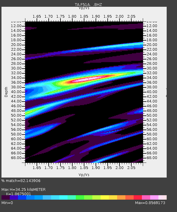
F51A Arnstein, ON, CAN - Earthquake Result Viewer

Earthquake location: Queen Charlotte Islands Region
Earthquake latitude/longitude: 51.2/-130.4
Earthquake time(UTC): 2013/09/03 (246) 20:19:06 GMT
Earthquake Depth: 2.7 km
Earthquake Magnitude: 6.1 MWW, 6.0 MWB, 6.1 MWW, 6.1 MWC, 6.2 MI, 6.2 MWC
Earthquake Catalog/Contributor: NEIC PDE/NEIC COMCAT
Network: TA USArray Transportable Network (new EarthScope stations)
Station: F51A Arnstein, ON, CAN
Lat/Lon: 45.93 N/79.92 W
Elevation: 239 m
Distance: 33.3 deg
Az: 78.995 deg
Baz: 297.871 deg
Ray Param: 0.07830258
Estimated Moho Depth: 34.25 km
Estimated Crust Vp/Vs: 1.87
Assumed Crust Vp: 6.577 km/s
Estimated Crust Vs: 3.522 km/s
Estimated Crust Poisson's Ratio: 0.30
Radial Match: 82.143906 %
Radial Bump: 398
Transverse Match: 56.275406 %
Transverse Bump: 400
SOD ConfigId: 626651
Insert Time: 2014-04-18 08:40:17.409 +0000
GWidth: 2.5
Max Bumps: 400
Tol: 0.001

Signal To Noise

ChannelStoNSTALTA
TA:F51A: :BHZ:20130903T20:25:14.149998Z3.2730065.386605E-71.645767E-7
TA:F51A: :BHN:20130903T20:25:14.149998Z1.84611551.9775702E-71.0712061E-7
TA:F51A: :BHE:20130903T20:25:14.149998Z2.45059922.3513901E-79.595164E-8
Arrivals
Ps4.9 SECOND
PpPs14 SECOND
PsPs/PpSs19 SECOND