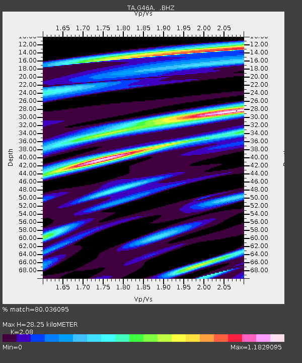
G46A Petoskey, MI, USA - Earthquake Result Viewer

Earthquake location: Queen Charlotte Islands Region
Earthquake latitude/longitude: 51.2/-130.4
Earthquake time(UTC): 2013/09/03 (246) 20:19:06 GMT
Earthquake Depth: 2.7 km
Earthquake Magnitude: 6.1 MWW, 6.0 MWB, 6.1 MWW, 6.1 MWC, 6.2 MI, 6.2 MWC
Earthquake Catalog/Contributor: NEIC PDE/NEIC COMCAT
Network: TA USArray Transportable Network (new EarthScope stations)
Station: G46A Petoskey, MI, USA
Lat/Lon: 45.32 N/84.86 W
Elevation: 239 m
Distance: 30.5 deg
Az: 83.088 deg
Baz: 297.823 deg
Ray Param: 0.07933014
Estimated Moho Depth: 28.25 km
Estimated Crust Vp/Vs: 2.08
Assumed Crust Vp: 6.483 km/s
Estimated Crust Vs: 3.117 km/s
Estimated Crust Poisson's Ratio: 0.35
Radial Match: 80.036095 %
Radial Bump: 400
Transverse Match: 48.14756 %
Transverse Bump: 400
SOD ConfigId: 626651
Insert Time: 2014-04-18 08:40:26.846 +0000
GWidth: 2.5
Max Bumps: 400
Tol: 0.001

Signal To Noise

ChannelStoNSTALTA
TA:G46A: :BHZ:20130903T20:24:49.72501Z3.6617077.400246E-72.0209825E-7
TA:G46A: :BHN:20130903T20:24:49.72501Z1.45413463.732587E-72.5668785E-7
TA:G46A: :BHE:20130903T20:24:49.72501Z2.27908595.953612E-72.6122805E-7
Arrivals
Ps5.0 SECOND
PpPs13 SECOND
PsPs/PpSs18 SECOND