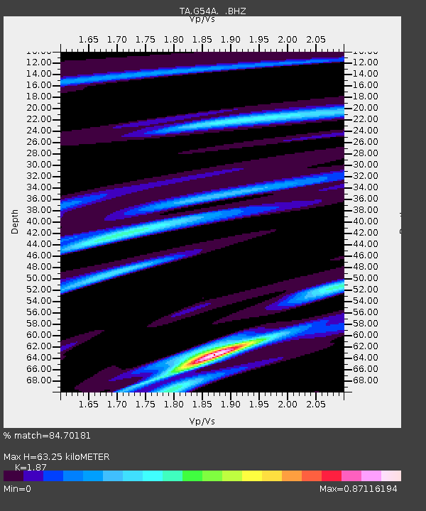
G54A Lake Saint Peter, ON, CAN - Earthquake Result Viewer

Earthquake location: Queen Charlotte Islands Region
Earthquake latitude/longitude: 51.2/-130.4
Earthquake time(UTC): 2013/09/03 (246) 20:19:06 GMT
Earthquake Depth: 2.7 km
Earthquake Magnitude: 6.1 MWW, 6.0 MWB, 6.1 MWW, 6.1 MWC, 6.2 MI, 6.2 MWC
Earthquake Catalog/Contributor: NEIC PDE/NEIC COMCAT
Network: TA USArray Transportable Network (new EarthScope stations)
Station: G54A Lake Saint Peter, ON, CAN
Lat/Lon: 45.40 N/78.09 W
Elevation: 465 m
Distance: 34.6 deg
Az: 78.74 deg
Baz: 298.961 deg
Ray Param: 0.07765267
Estimated Moho Depth: 63.25 km
Estimated Crust Vp/Vs: 1.87
Assumed Crust Vp: 6.577 km/s
Estimated Crust Vs: 3.517 km/s
Estimated Crust Poisson's Ratio: 0.30
Radial Match: 84.70181 %
Radial Bump: 297
Transverse Match: 54.07949 %
Transverse Bump: 400
SOD ConfigId: 626651
Insert Time: 2014-04-18 08:40:32.987 +0000
GWidth: 2.5
Max Bumps: 400
Tol: 0.001

Signal To Noise

ChannelStoNSTALTA
TA:G54A: :BHZ:20130903T20:25:26.074985Z3.6870185.25146E-71.4243109E-7
TA:G54A: :BHN:20130903T20:25:26.074985Z1.60998652.6346507E-71.6364427E-7
TA:G54A: :BHE:20130903T20:25:26.074985Z2.40906743.3769402E-71.4017624E-7
Arrivals
Ps9.0 SECOND
PpPs26 SECOND
PsPs/PpSs35 SECOND