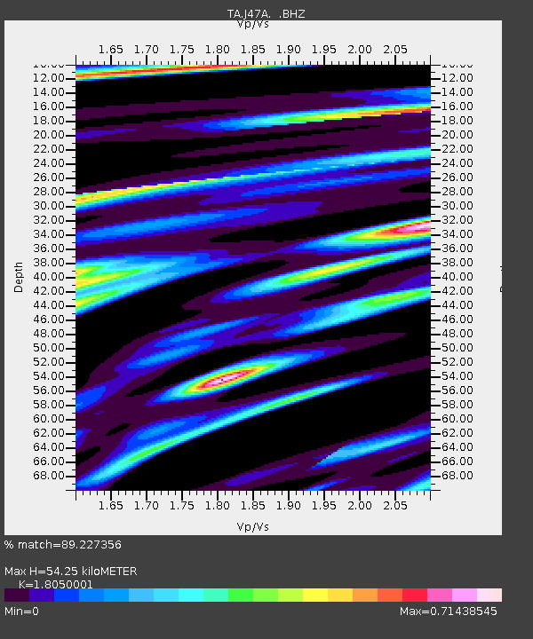
J47A Sunmer, MI, USA - Earthquake Result Viewer

Earthquake location: Queen Charlotte Islands Region
Earthquake latitude/longitude: 51.2/-130.4
Earthquake time(UTC): 2013/09/03 (246) 20:19:06 GMT
Earthquake Depth: 2.7 km
Earthquake Magnitude: 6.1 MWW, 6.0 MWB, 6.1 MWW, 6.1 MWC, 6.2 MI, 6.2 MWC
Earthquake Catalog/Contributor: NEIC PDE/NEIC COMCAT
Network: TA USArray Transportable Network (new EarthScope stations)
Station: J47A Sunmer, MI, USA
Lat/Lon: 43.24 N/84.82 W
Elevation: 236 m
Distance: 31.5 deg
Az: 86.58 deg
Baz: 300.844 deg
Ray Param: 0.079054914
Estimated Moho Depth: 54.25 km
Estimated Crust Vp/Vs: 1.81
Assumed Crust Vp: 6.483 km/s
Estimated Crust Vs: 3.591 km/s
Estimated Crust Poisson's Ratio: 0.28
Radial Match: 89.227356 %
Radial Bump: 400
Transverse Match: 53.24962 %
Transverse Bump: 400
SOD ConfigId: 626651
Insert Time: 2014-04-18 08:41:21.508 +0000
GWidth: 2.5
Max Bumps: 400
Tol: 0.001

Signal To Noise

ChannelStoNSTALTA
TA:J47A: :BHZ:20130903T20:24:58.924991Z3.81519416.1216315E-71.60454E-7
TA:J47A: :BHN:20130903T20:24:58.924991Z1.12504852.54339E-72.2606936E-7
TA:J47A: :BHE:20130903T20:24:58.924991Z2.06964764.600787E-72.222981E-7
Arrivals
Ps7.3 SECOND
PpPs22 SECOND
PsPs/PpSs29 SECOND