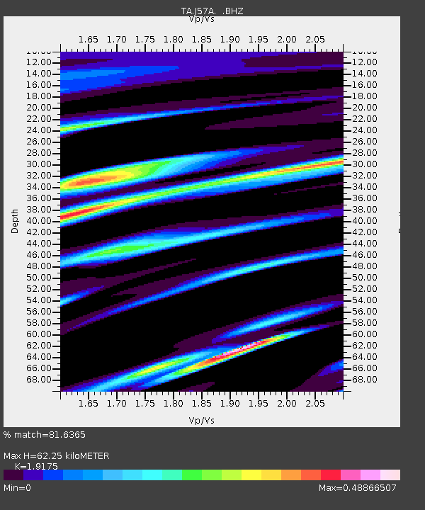
J57A Williamstown, NY, USA - Earthquake Result Viewer
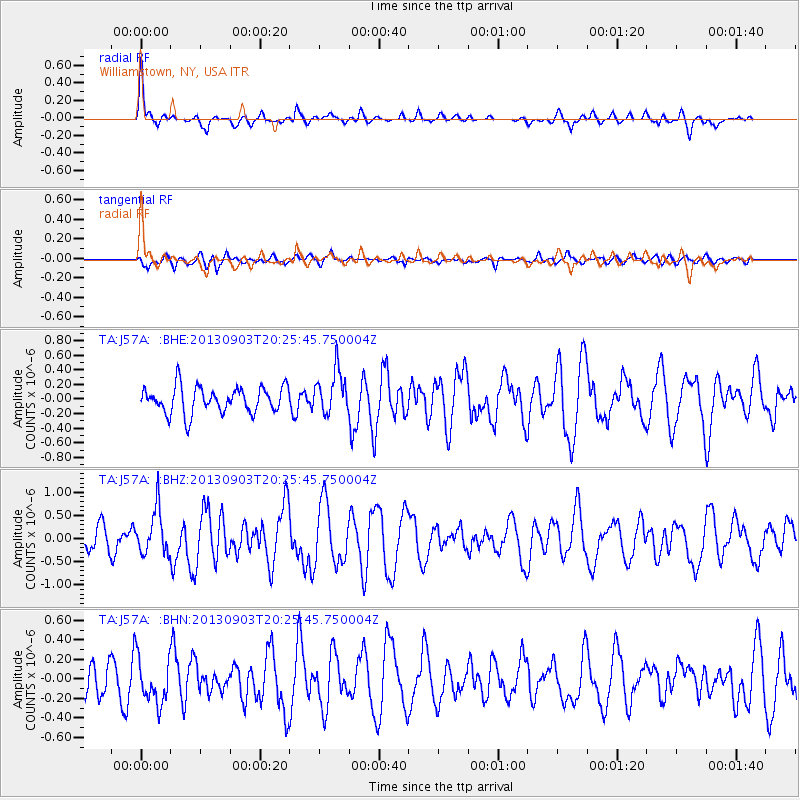
Earthquake location: Queen Charlotte Islands Region
Earthquake latitude/longitude: 51.2/-130.4
Earthquake time(UTC): 2013/09/03 (246) 20:19:06 GMT
Earthquake Depth: 2.7 km
Earthquake Magnitude: 6.1 MWW, 6.0 MWB, 6.1 MWW, 6.1 MWC, 6.2 MI, 6.2 MWC
Earthquake Catalog/Contributor: NEIC PDE/NEIC COMCAT
Network: TA USArray Transportable Network (new EarthScope stations)
Station: J57A Williamstown, NY, USA
Lat/Lon: 43.41 N/76.00 W
Elevation: 191 m
Distance: 36.9 deg
Az: 80.376 deg
Baz: 301.748 deg
Ray Param: 0.076423556
Estimated Moho Depth: 62.25 km
Estimated Crust Vp/Vs: 1.92
Assumed Crust Vp: 6.419 km/s
Estimated Crust Vs: 3.348 km/s
Estimated Crust Poisson's Ratio: 0.31
Radial Match: 81.6365 %
Radial Bump: 324
Transverse Match: 60.343376 %
Transverse Bump: 400
SOD ConfigId: 626651
Insert Time: 2014-04-18 08:41:33.761 +0000
GWidth: 2.5
Max Bumps: 400
Tol: 0.001

Signal To Noise

ChannelStoNSTALTA
TA:J57A: :BHZ:20130903T20:25:45.750004Z1.96587124.836698E-72.4603332E-7
TA:J57A: :BHN:20130903T20:25:45.750004Z1.36038572.295066E-71.68707E-7
TA:J57A: :BHE:20130903T20:25:45.750004Z1.64352922.963608E-71.8031977E-7
Arrivals
Ps9.5 SECOND
PpPs26 SECOND
PsPs/PpSs36 SECOND