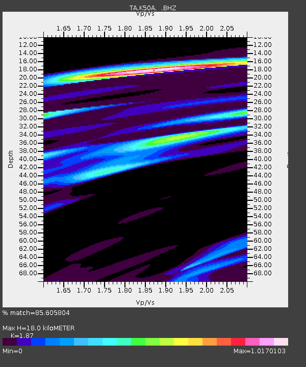
K50A Casco, MI, USA - Earthquake Result Viewer
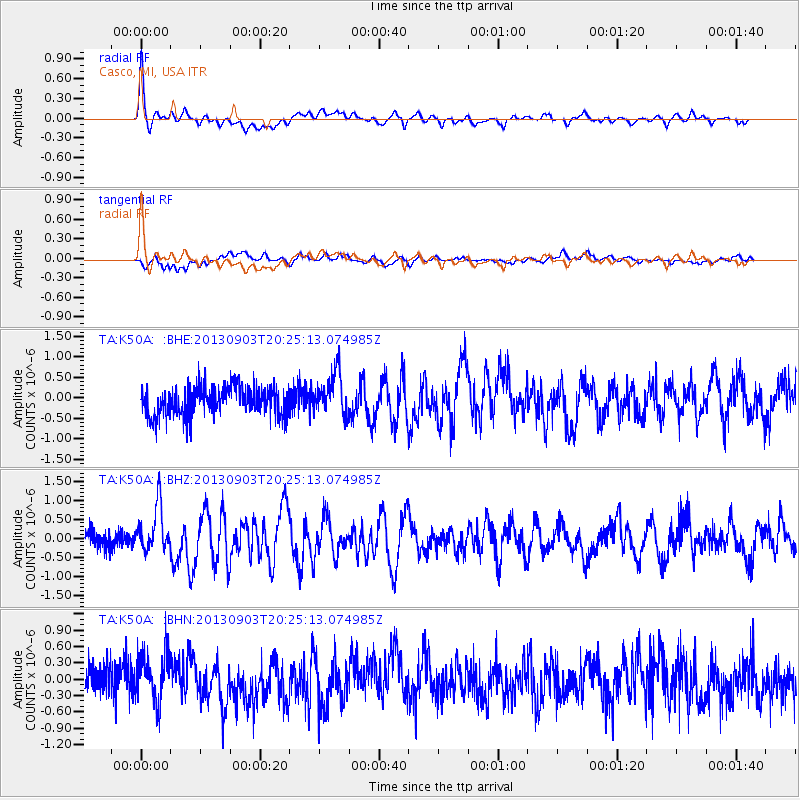
Earthquake location: Queen Charlotte Islands Region
Earthquake latitude/longitude: 51.2/-130.4
Earthquake time(UTC): 2013/09/03 (246) 20:19:06 GMT
Earthquake Depth: 2.7 km
Earthquake Magnitude: 6.1 MWW, 6.0 MWB, 6.1 MWW, 6.1 MWC, 6.2 MI, 6.2 MWC
Earthquake Catalog/Contributor: NEIC PDE/NEIC COMCAT
Network: TA USArray Transportable Network (new EarthScope stations)
Station: K50A Casco, MI, USA
Lat/Lon: 42.77 N/82.62 W
Elevation: 191 m
Distance: 33.1 deg
Az: 85.756 deg
Baz: 301.643 deg
Ray Param: 0.078359365
Estimated Moho Depth: 18.0 km
Estimated Crust Vp/Vs: 1.87
Assumed Crust Vp: 6.483 km/s
Estimated Crust Vs: 3.467 km/s
Estimated Crust Poisson's Ratio: 0.30
Radial Match: 85.605804 %
Radial Bump: 400
Transverse Match: 59.346188 %
Transverse Bump: 400
SOD ConfigId: 626651
Insert Time: 2014-04-18 08:41:48.596 +0000
GWidth: 2.5
Max Bumps: 400
Tol: 0.001

Signal To Noise

ChannelStoNSTALTA
TA:K50A: :BHZ:20130903T20:25:13.074985Z2.75366.075257E-72.2062963E-7
TA:K50A: :BHN:20130903T20:25:13.074985Z1.25551084.3950075E-73.5005735E-7
TA:K50A: :BHE:20130903T20:25:13.074985Z1.47015125.2104656E-73.54417E-7
Arrivals
Ps2.6 SECOND
PpPs7.4 SECOND
PsPs/PpSs10.0 SECOND