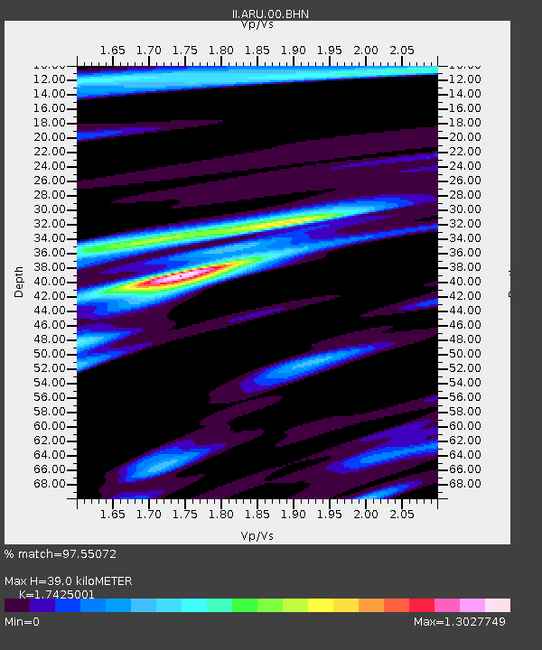
ARU Arti, Russia - Earthquake Result Viewer

Earthquake location: Kodiak Island Region, Alaska
Earthquake latitude/longitude: 57.1/-153.2
Earthquake time(UTC): 2001/01/10 (010) 16:02:44 GMT
Earthquake Depth: 33 km
Earthquake Magnitude: 6.2 MB, 6.8 MS, 7.1 MW, 6.8 ML
Earthquake Catalog/Contributor: WHDF/NEIC
Network: II Global Seismograph Network (GSN - IRIS/IDA)
Station: ARU Arti, Russia
Lat/Lon: 56.43 N/58.56 E
Elevation: 250 m
Distance: 64.0 deg
Az: 341.003 deg
Baz: 18.661 deg
Ray Param: 0.059166852
Estimated Moho Depth: 39.0 km
Estimated Crust Vp/Vs: 1.74
Assumed Crust Vp: 6.159 km/s
Estimated Crust Vs: 3.534 km/s
Estimated Crust Poisson's Ratio: 0.25
Radial Match: 97.55072 %
Radial Bump: 400
Transverse Match: 84.46054 %
Transverse Bump: 400
SOD ConfigId: 3744
Insert Time: 2010-03-01 16:28:22.458 +0000
GWidth: 2.5
Max Bumps: 400
Tol: 0.001

Signal To Noise

ChannelStoNSTALTA
II:ARU:00:BHN:20010110T16:12:43.482014Z10.48382951.935489E-61.8461662E-7
II:ARU:00:BHE:20010110T16:12:43.482014Z8.4048768.175876E-79.727539E-8
II:ARU:00:BHZ:20010110T16:12:43.482014Z35.9576844.396915E-61.2228026E-7
Arrivals
Ps4.9 SECOND
PpPs17 SECOND
PsPs/PpSs22 SECOND