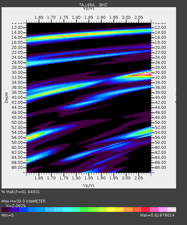
L49A Milan, MI, USA - Earthquake Result Viewer
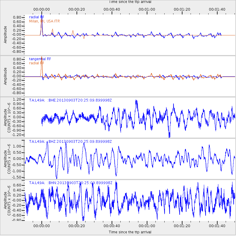
Earthquake location: Queen Charlotte Islands Region
Earthquake latitude/longitude: 51.2/-130.4
Earthquake time(UTC): 2013/09/03 (246) 20:19:06 GMT
Earthquake Depth: 2.7 km
Earthquake Magnitude: 6.1 MWW, 6.0 MWB, 6.1 MWW, 6.1 MWC, 6.2 MI, 6.2 MWC
Earthquake Catalog/Contributor: NEIC PDE/NEIC COMCAT
Network: TA USArray Transportable Network (new EarthScope stations)
Station: L49A Milan, MI, USA
Lat/Lon: 42.11 N/83.77 W
Elevation: 230 m
Distance: 32.8 deg
Az: 87.619 deg
Baz: 302.436 deg
Ray Param: 0.07852149
Estimated Moho Depth: 30.0 km
Estimated Crust Vp/Vs: 2.09
Assumed Crust Vp: 6.483 km/s
Estimated Crust Vs: 3.098 km/s
Estimated Crust Poisson's Ratio: 0.35
Radial Match: 81.84831 %
Radial Bump: 285
Transverse Match: 66.56127 %
Transverse Bump: 400
SOD ConfigId: 626651
Insert Time: 2014-04-18 08:42:16.659 +0000
GWidth: 2.5
Max Bumps: 400
Tol: 0.001

Signal To Noise

ChannelStoNSTALTA
TA:L49A: :BHZ:20130903T20:25:09.899998Z3.12238226.0088746E-71.924452E-7
TA:L49A: :BHN:20130903T20:25:09.899998Z1.60263493.320513E-72.0719085E-7
TA:L49A: :BHE:20130903T20:25:09.899998Z1.64214523.245674E-71.9764842E-7
Arrivals
Ps5.4 SECOND
PpPs13 SECOND
PsPs/PpSs19 SECOND