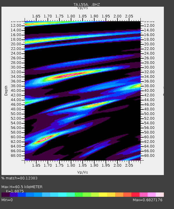
L55A Hinsdale, NY, USA - Earthquake Result Viewer
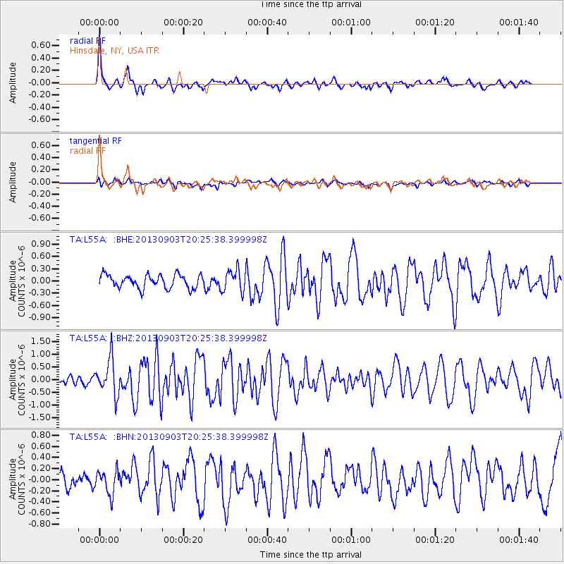
Earthquake location: Queen Charlotte Islands Region
Earthquake latitude/longitude: 51.2/-130.4
Earthquake time(UTC): 2013/09/03 (246) 20:19:06 GMT
Earthquake Depth: 2.7 km
Earthquake Magnitude: 6.1 MWW, 6.0 MWB, 6.1 MWW, 6.1 MWC, 6.2 MI, 6.2 MWC
Earthquake Catalog/Contributor: NEIC PDE/NEIC COMCAT
Network: TA USArray Transportable Network (new EarthScope stations)
Station: L55A Hinsdale, NY, USA
Lat/Lon: 42.18 N/78.44 W
Elevation: 633 m
Distance: 36.1 deg
Az: 83.73 deg
Baz: 302.792 deg
Ray Param: 0.07689453
Estimated Moho Depth: 60.5 km
Estimated Crust Vp/Vs: 1.69
Assumed Crust Vp: 6.419 km/s
Estimated Crust Vs: 3.804 km/s
Estimated Crust Poisson's Ratio: 0.23
Radial Match: 80.12383 %
Radial Bump: 399
Transverse Match: 61.970825 %
Transverse Bump: 400
SOD ConfigId: 626651
Insert Time: 2014-04-18 08:42:26.183 +0000
GWidth: 2.5
Max Bumps: 400
Tol: 0.001

Signal To Noise

ChannelStoNSTALTA
TA:L55A: :BHZ:20130903T20:25:38.399998Z4.0190057.2935006E-71.8147529E-7
TA:L55A: :BHN:20130903T20:25:38.399998Z1.42227422.1820387E-71.53419E-7
TA:L55A: :BHE:20130903T20:25:38.399998Z1.6648592.6976755E-71.6203626E-7
Arrivals
Ps7.0 SECOND
PpPs23 SECOND
PsPs/PpSs30 SECOND