M56A Emporium, PA, USA - Earthquake Result Viewer
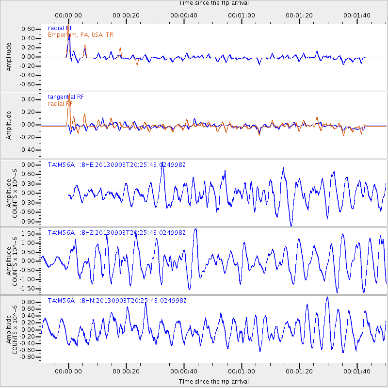
Earthquake location: Queen Charlotte Islands Region
Earthquake latitude/longitude: 51.2/-130.4
Earthquake time(UTC): 2013/09/03 (246) 20:19:06 GMT
Earthquake Depth: 2.7 km
Earthquake Magnitude: 6.1 MWW, 6.0 MWB, 6.1 MWW, 6.1 MWC, 6.2 MI, 6.2 MWC
Earthquake Catalog/Contributor: NEIC PDE/NEIC COMCAT
Network: TA USArray Transportable Network (new EarthScope stations)
Station: M56A Emporium, PA, USA
Lat/Lon: 41.48 N/78.18 W
Elevation: 493 m
Distance: 36.6 deg
Az: 84.541 deg
Baz: 303.614 deg
Ray Param: 0.07659937
Estimated Moho Depth: 31.75 km
Estimated Crust Vp/Vs: 2.01
Assumed Crust Vp: 6.121 km/s
Estimated Crust Vs: 3.045 km/s
Estimated Crust Poisson's Ratio: 0.34
Radial Match: 85.03457 %
Radial Bump: 400
Transverse Match: 57.5306 %
Transverse Bump: 400
SOD ConfigId: 626651
Insert Time: 2014-04-18 08:42:54.485 +0000
GWidth: 2.5
Max Bumps: 400
Tol: 0.001

Signal To Noise

ChannelStoNSTALTA
TA:M56A: :BHZ:20130903T20:25:43.024998Z3.79973556.312533E-71.6613085E-7
TA:M56A: :BHN:20130903T20:25:43.024998Z2.06756542.8781287E-71.3920376E-7
TA:M56A: :BHE:20130903T20:25:43.024998Z3.14189894.576247E-71.4565228E-7
Arrivals
Ps5.6 SECOND
PpPs15 SECOND
PsPs/PpSs20 SECOND