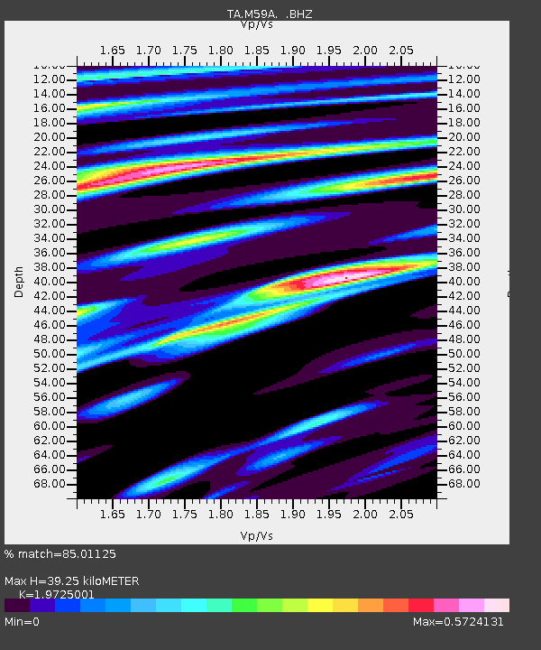
M59A Waymart, PA, USA - Earthquake Result Viewer
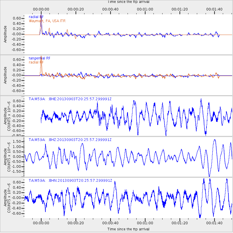
Earthquake location: Queen Charlotte Islands Region
Earthquake latitude/longitude: 51.2/-130.4
Earthquake time(UTC): 2013/09/03 (246) 20:19:06 GMT
Earthquake Depth: 2.7 km
Earthquake Magnitude: 6.1 MWW, 6.0 MWB, 6.1 MWW, 6.1 MWC, 6.2 MI, 6.2 MWC
Earthquake Catalog/Contributor: NEIC PDE/NEIC COMCAT
Network: TA USArray Transportable Network (new EarthScope stations)
Station: M59A Waymart, PA, USA
Lat/Lon: 41.54 N/75.43 W
Elevation: 471 m
Distance: 38.3 deg
Az: 82.576 deg
Baz: 303.871 deg
Ray Param: 0.07565686
Estimated Moho Depth: 39.25 km
Estimated Crust Vp/Vs: 1.97
Assumed Crust Vp: 6.283 km/s
Estimated Crust Vs: 3.185 km/s
Estimated Crust Poisson's Ratio: 0.33
Radial Match: 85.01125 %
Radial Bump: 400
Transverse Match: 60.121098 %
Transverse Bump: 400
SOD ConfigId: 626651
Insert Time: 2014-04-18 08:42:59.525 +0000
GWidth: 2.5
Max Bumps: 400
Tol: 0.001

Signal To Noise

ChannelStoNSTALTA
TA:M59A: :BHZ:20130903T20:25:57.299991Z2.1439754.6368928E-72.1627551E-7
TA:M59A: :BHN:20130903T20:25:57.299991Z2.06020882.0224677E-79.8168094E-8
TA:M59A: :BHE:20130903T20:25:57.299991Z1.72267972.171484E-71.2605267E-7
Arrivals
Ps6.5 SECOND
PpPs17 SECOND
PsPs/PpSs24 SECOND