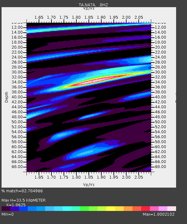
N47A Urbana, IN, USA - Earthquake Result Viewer

Earthquake location: Queen Charlotte Islands Region
Earthquake latitude/longitude: 51.2/-130.4
Earthquake time(UTC): 2013/09/03 (246) 20:19:06 GMT
Earthquake Depth: 2.7 km
Earthquake Magnitude: 6.1 MWW, 6.0 MWB, 6.1 MWW, 6.1 MWC, 6.2 MI, 6.2 MWC
Earthquake Catalog/Contributor: NEIC PDE/NEIC COMCAT
Network: TA USArray Transportable Network (new EarthScope stations)
Station: N47A Urbana, IN, USA
Lat/Lon: 40.88 N/85.69 W
Elevation: 252 m
Distance: 32.2 deg
Az: 91.006 deg
Baz: 304.021 deg
Ray Param: 0.07875053
Estimated Moho Depth: 33.5 km
Estimated Crust Vp/Vs: 1.86
Assumed Crust Vp: 6.498 km/s
Estimated Crust Vs: 3.489 km/s
Estimated Crust Poisson's Ratio: 0.30
Radial Match: 82.784966 %
Radial Bump: 400
Transverse Match: 65.66179 %
Transverse Bump: 400
SOD ConfigId: 626651
Insert Time: 2014-04-18 08:43:09.198 +0000
GWidth: 2.5
Max Bumps: 400
Tol: 0.001

Signal To Noise

ChannelStoNSTALTA
TA:N47A: :BHZ:20130903T20:25:05.199985Z5.57502176.8023166E-71.2201416E-7
TA:N47A: :BHN:20130903T20:25:05.199985Z2.70553182.669538E-79.866962E-8
TA:N47A: :BHE:20130903T20:25:05.199985Z3.17688683.8624339E-71.215792E-7
Arrivals
Ps4.8 SECOND
PpPs14 SECOND
PsPs/PpSs18 SECOND