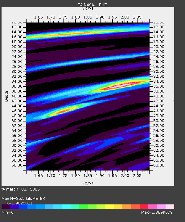
N49A Columbus Grove, OH, USA - Earthquake Result Viewer

Earthquake location: Queen Charlotte Islands Region
Earthquake latitude/longitude: 51.2/-130.4
Earthquake time(UTC): 2013/09/03 (246) 20:19:06 GMT
Earthquake Depth: 2.7 km
Earthquake Magnitude: 6.1 MWW, 6.0 MWB, 6.1 MWW, 6.1 MWC, 6.2 MI, 6.2 MWC
Earthquake Catalog/Contributor: NEIC PDE/NEIC COMCAT
Network: TA USArray Transportable Network (new EarthScope stations)
Station: N49A Columbus Grove, OH, USA
Lat/Lon: 40.92 N/84.18 W
Elevation: 225 m
Distance: 33.2 deg
Az: 89.756 deg
Baz: 303.955 deg
Ray Param: 0.078348376
Estimated Moho Depth: 35.5 km
Estimated Crust Vp/Vs: 1.98
Assumed Crust Vp: 6.498 km/s
Estimated Crust Vs: 3.277 km/s
Estimated Crust Poisson's Ratio: 0.33
Radial Match: 88.75305 %
Radial Bump: 241
Transverse Match: 65.00759 %
Transverse Bump: 400
SOD ConfigId: 626651
Insert Time: 2014-04-18 08:43:13.880 +0000
GWidth: 2.5
Max Bumps: 400
Tol: 0.001

Signal To Noise

ChannelStoNSTALTA
TA:N49A: :BHZ:20130903T20:25:13.274998Z4.2190075.143078E-71.2190257E-7
TA:N49A: :BHN:20130903T20:25:13.274998Z2.26631522.6193857E-71.15579056E-7
TA:N49A: :BHE:20130903T20:25:13.274998Z1.66814512.3709146E-71.421288E-7
Arrivals
Ps5.8 SECOND
PpPs15 SECOND
PsPs/PpSs21 SECOND