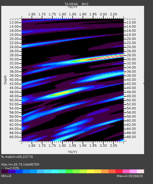
N54A Moraine State Park, Portersville, PA, USA - Earthquake Result Viewer
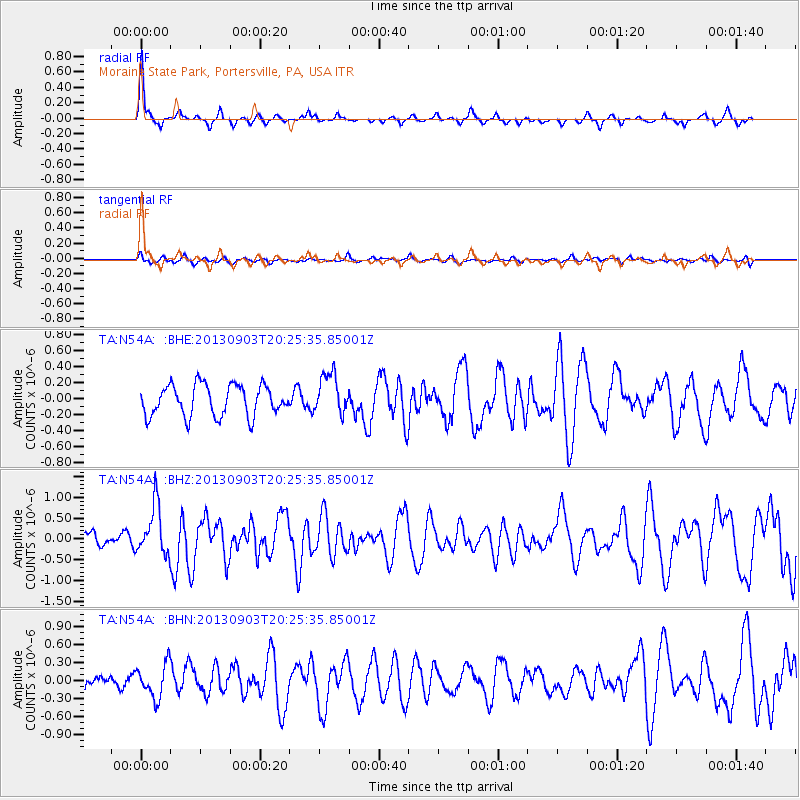
Earthquake location: Queen Charlotte Islands Region
Earthquake latitude/longitude: 51.2/-130.4
Earthquake time(UTC): 2013/09/03 (246) 20:19:06 GMT
Earthquake Depth: 2.7 km
Earthquake Magnitude: 6.1 MWW, 6.0 MWB, 6.1 MWW, 6.1 MWC, 6.2 MI, 6.2 MWC
Earthquake Catalog/Contributor: NEIC PDE/NEIC COMCAT
Network: TA USArray Transportable Network (new EarthScope stations)
Station: N54A Moraine State Park, Portersville, PA, USA
Lat/Lon: 40.96 N/79.99 W
Elevation: 408 m
Distance: 35.8 deg
Az: 86.56 deg
Baz: 304.057 deg
Ray Param: 0.07705787
Estimated Moho Depth: 28.75 km
Estimated Crust Vp/Vs: 2.03
Assumed Crust Vp: 6.121 km/s
Estimated Crust Vs: 3.022 km/s
Estimated Crust Poisson's Ratio: 0.34
Radial Match: 85.03778 %
Radial Bump: 288
Transverse Match: 51.552155 %
Transverse Bump: 400
SOD ConfigId: 626651
Insert Time: 2014-04-18 08:43:23.136 +0000
GWidth: 2.5
Max Bumps: 400
Tol: 0.001

Signal To Noise

ChannelStoNSTALTA
TA:N54A: :BHZ:20130903T20:25:35.85001Z3.05382755.972023E-71.9555863E-7
TA:N54A: :BHN:20130903T20:25:35.85001Z1.98158052.7837584E-71.4048172E-7
TA:N54A: :BHE:20130903T20:25:35.85001Z1.32540332.547684E-71.9221952E-7
Arrivals
Ps5.1 SECOND
PpPs13 SECOND
PsPs/PpSs19 SECOND