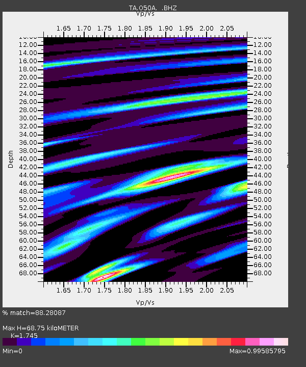
O50A Cable, OH, USA - Earthquake Result Viewer

Earthquake location: Queen Charlotte Islands Region
Earthquake latitude/longitude: 51.2/-130.4
Earthquake time(UTC): 2013/09/03 (246) 20:19:06 GMT
Earthquake Depth: 2.7 km
Earthquake Magnitude: 6.1 MWW, 6.0 MWB, 6.1 MWW, 6.1 MWC, 6.2 MI, 6.2 MWC
Earthquake Catalog/Contributor: NEIC PDE/NEIC COMCAT
Network: TA USArray Transportable Network (new EarthScope stations)
Station: O50A Cable, OH, USA
Lat/Lon: 40.15 N/83.62 W
Elevation: 399 m
Distance: 34.0 deg
Az: 90.473 deg
Baz: 304.917 deg
Ray Param: 0.07798357
Estimated Moho Depth: 68.75 km
Estimated Crust Vp/Vs: 1.75
Assumed Crust Vp: 6.498 km/s
Estimated Crust Vs: 3.724 km/s
Estimated Crust Poisson's Ratio: 0.26
Radial Match: 88.28087 %
Radial Bump: 400
Transverse Match: 66.8896 %
Transverse Bump: 400
SOD ConfigId: 626651
Insert Time: 2014-04-18 08:43:45.597 +0000
GWidth: 2.5
Max Bumps: 400
Tol: 0.001

Signal To Noise

ChannelStoNSTALTA
TA:O50A: :BHZ:20130903T20:25:20.174991Z5.18730076.114997E-71.17883985E-7
TA:O50A: :BHN:20130903T20:25:20.174991Z1.4932721.9917282E-71.3338013E-7
TA:O50A: :BHE:20130903T20:25:20.174991Z2.09644843.1729522E-71.5134893E-7
Arrivals
Ps8.5 SECOND
PpPs27 SECOND
PsPs/PpSs35 SECOND