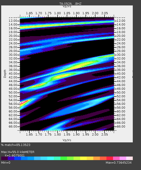
O52A Adamsville, OH, USA - Earthquake Result Viewer

Earthquake location: Queen Charlotte Islands Region
Earthquake latitude/longitude: 51.2/-130.4
Earthquake time(UTC): 2013/09/03 (246) 20:19:06 GMT
Earthquake Depth: 2.7 km
Earthquake Magnitude: 6.1 MWW, 6.0 MWB, 6.1 MWW, 6.1 MWC, 6.2 MI, 6.2 MWC
Earthquake Catalog/Contributor: NEIC PDE/NEIC COMCAT
Network: TA USArray Transportable Network (new EarthScope stations)
Station: O52A Adamsville, OH, USA
Lat/Lon: 40.12 N/81.84 W
Elevation: 331 m
Distance: 35.1 deg
Az: 89.136 deg
Baz: 304.96 deg
Ray Param: 0.07741819
Estimated Moho Depth: 55.0 km
Estimated Crust Vp/Vs: 1.61
Assumed Crust Vp: 6.483 km/s
Estimated Crust Vs: 4.033 km/s
Estimated Crust Poisson's Ratio: 0.18
Radial Match: 85.13523 %
Radial Bump: 255
Transverse Match: 49.479492 %
Transverse Bump: 400
SOD ConfigId: 626651
Insert Time: 2014-04-18 08:43:49.966 +0000
GWidth: 2.5
Max Bumps: 400
Tol: 0.001

Signal To Noise

ChannelStoNSTALTA
TA:O52A: :BHZ:20130903T20:25:30.000004Z4.6795025.59716E-71.1961015E-7
TA:O52A: :BHN:20130903T20:25:30.000004Z2.35992122.5637763E-71.0863821E-7
TA:O52A: :BHE:20130903T20:25:30.000004Z2.81570224.8505126E-71.7226654E-7
Arrivals
Ps5.6 SECOND
PpPs20 SECOND
PsPs/PpSs26 SECOND