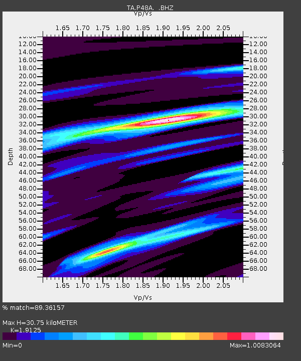
P48A Milroy, IN, USA - Earthquake Result Viewer

Earthquake location: Queen Charlotte Islands Region
Earthquake latitude/longitude: 51.2/-130.4
Earthquake time(UTC): 2013/09/03 (246) 20:19:06 GMT
Earthquake Depth: 2.7 km
Earthquake Magnitude: 6.1 MWW, 6.0 MWB, 6.1 MWW, 6.1 MWC, 6.2 MI, 6.2 MWC
Earthquake Catalog/Contributor: NEIC PDE/NEIC COMCAT
Network: TA USArray Transportable Network (new EarthScope stations)
Station: P48A Milroy, IN, USA
Lat/Lon: 39.46 N/85.43 W
Elevation: 300 m
Distance: 33.2 deg
Az: 92.939 deg
Baz: 305.819 deg
Ray Param: 0.07832341
Estimated Moho Depth: 30.75 km
Estimated Crust Vp/Vs: 1.91
Assumed Crust Vp: 6.498 km/s
Estimated Crust Vs: 3.397 km/s
Estimated Crust Poisson's Ratio: 0.31
Radial Match: 89.36157 %
Radial Bump: 334
Transverse Match: 66.451294 %
Transverse Bump: 400
SOD ConfigId: 626651
Insert Time: 2014-04-18 08:44:16.474 +0000
GWidth: 2.5
Max Bumps: 400
Tol: 0.001

Signal To Noise

ChannelStoNSTALTA
TA:P48A: :BHZ:20130903T20:25:13.750004Z6.76564849.899527E-71.4632046E-7
TA:P48A: :BHN:20130903T20:25:13.750004Z2.4565163.217895E-71.3099427E-7
TA:P48A: :BHE:20130903T20:25:13.750004Z3.20948054.909548E-71.5297016E-7
Arrivals
Ps4.7 SECOND
PpPs13 SECOND
PsPs/PpSs17 SECOND