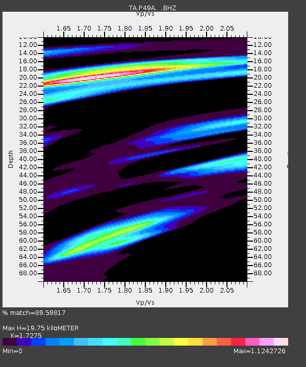
P49A Miami Univ. Ecology Research Center, OH, USA - Earthquake Result Viewer

Earthquake location: Queen Charlotte Islands Region
Earthquake latitude/longitude: 51.2/-130.4
Earthquake time(UTC): 2013/09/03 (246) 20:19:06 GMT
Earthquake Depth: 2.7 km
Earthquake Magnitude: 6.1 MWW, 6.0 MWB, 6.1 MWW, 6.1 MWC, 6.2 MI, 6.2 MWC
Earthquake Catalog/Contributor: NEIC PDE/NEIC COMCAT
Network: TA USArray Transportable Network (new EarthScope stations)
Station: P49A Miami Univ. Ecology Research Center, OH, USA
Lat/Lon: 39.53 N/84.72 W
Elevation: 272 m
Distance: 33.6 deg
Az: 92.248 deg
Baz: 305.692 deg
Ray Param: 0.07813806
Estimated Moho Depth: 19.75 km
Estimated Crust Vp/Vs: 1.73
Assumed Crust Vp: 6.498 km/s
Estimated Crust Vs: 3.761 km/s
Estimated Crust Poisson's Ratio: 0.25
Radial Match: 89.59817 %
Radial Bump: 400
Transverse Match: 62.770355 %
Transverse Bump: 400
SOD ConfigId: 626651
Insert Time: 2014-04-18 08:44:17.303 +0000
GWidth: 2.5
Max Bumps: 400
Tol: 0.001

Signal To Noise

ChannelStoNSTALTA
TA:P49A: :BHZ:20130903T20:25:17.250004Z3.00048695.875346E-71.9581309E-7
TA:P49A: :BHN:20130903T20:25:17.250004Z2.488833.0569552E-71.22827E-7
TA:P49A: :BHE:20130903T20:25:17.250004Z2.5157063.8714532E-71.5389134E-7
Arrivals
Ps2.4 SECOND
PpPs7.6 SECOND
PsPs/PpSs10 SECOND