P50A Jamestown, OH, USA - Earthquake Result Viewer
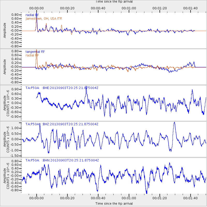
Earthquake location: Queen Charlotte Islands Region
Earthquake latitude/longitude: 51.2/-130.4
Earthquake time(UTC): 2013/09/03 (246) 20:19:06 GMT
Earthquake Depth: 2.7 km
Earthquake Magnitude: 6.1 MWW, 6.0 MWB, 6.1 MWW, 6.1 MWC, 6.2 MI, 6.2 MWC
Earthquake Catalog/Contributor: NEIC PDE/NEIC COMCAT
Network: TA USArray Transportable Network (new EarthScope stations)
Station: P50A Jamestown, OH, USA
Lat/Lon: 39.61 N/83.80 W
Elevation: 318 m
Distance: 34.2 deg
Az: 91.399 deg
Baz: 305.569 deg
Ray Param: 0.07789249
Estimated Moho Depth: 53.5 km
Estimated Crust Vp/Vs: 2.05
Assumed Crust Vp: 6.232 km/s
Estimated Crust Vs: 3.04 km/s
Estimated Crust Poisson's Ratio: 0.34
Radial Match: 83.0212 %
Radial Bump: 400
Transverse Match: 50.2612 %
Transverse Bump: 400
SOD ConfigId: 626651
Insert Time: 2014-04-18 08:44:21.199 +0000
GWidth: 2.5
Max Bumps: 400
Tol: 0.001

Signal To Noise

ChannelStoNSTALTA
TA:P50A: :BHZ:20130903T20:25:21.875004Z3.72122885.255265E-71.4122392E-7
TA:P50A: :BHN:20130903T20:25:21.875004Z0.35332221.6990113E-74.808674E-7
TA:P50A: :BHE:20130903T20:25:21.875004Z1.44938414.0032873E-72.7620612E-7
Arrivals
Ps9.6 SECOND
PpPs25 SECOND
PsPs/PpSs34 SECOND