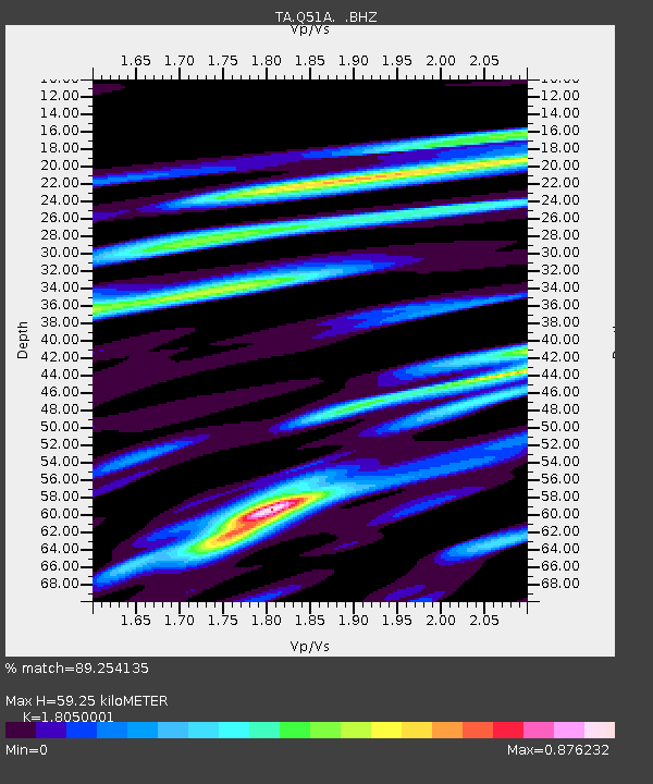
Q51A Peebles, OH, USA - Earthquake Result Viewer
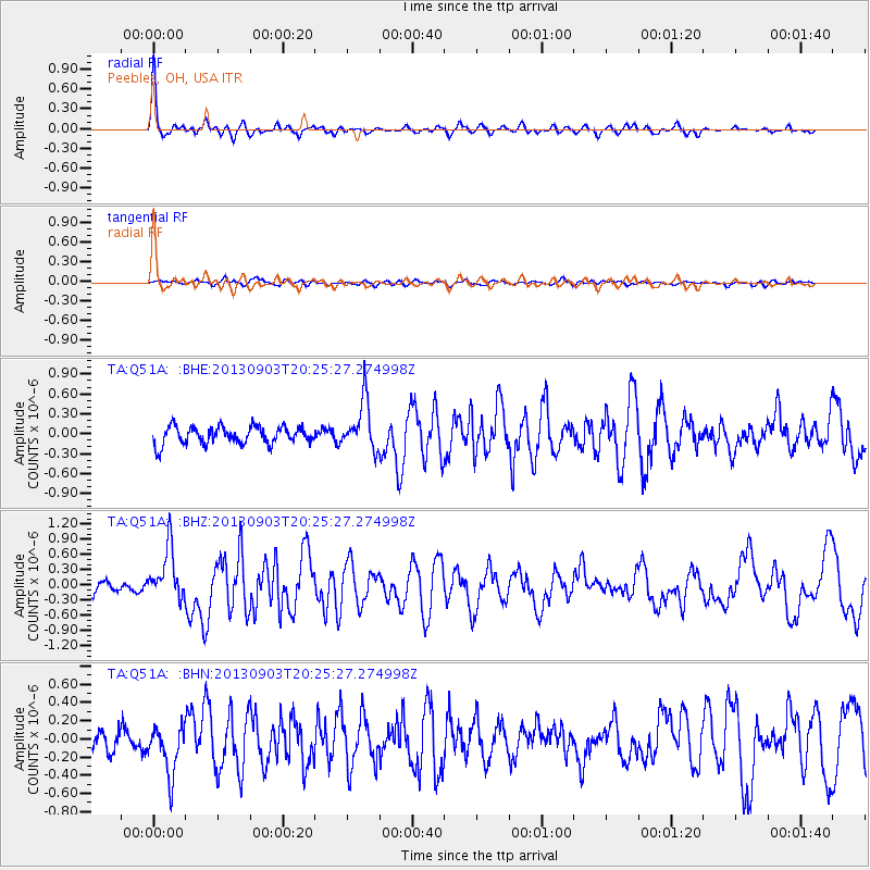
Earthquake location: Queen Charlotte Islands Region
Earthquake latitude/longitude: 51.2/-130.4
Earthquake time(UTC): 2013/09/03 (246) 20:19:06 GMT
Earthquake Depth: 2.7 km
Earthquake Magnitude: 6.1 MWW, 6.0 MWB, 6.1 MWW, 6.1 MWC, 6.2 MI, 6.2 MWC
Earthquake Catalog/Contributor: NEIC PDE/NEIC COMCAT
Network: TA USArray Transportable Network (new EarthScope stations)
Station: Q51A Peebles, OH, USA
Lat/Lon: 39.03 N/83.35 W
Elevation: 362 m
Distance: 34.8 deg
Az: 91.867 deg
Baz: 306.242 deg
Ray Param: 0.07758121
Estimated Moho Depth: 59.25 km
Estimated Crust Vp/Vs: 1.81
Assumed Crust Vp: 6.232 km/s
Estimated Crust Vs: 3.452 km/s
Estimated Crust Poisson's Ratio: 0.28
Radial Match: 89.254135 %
Radial Bump: 294
Transverse Match: 53.488747 %
Transverse Bump: 400
SOD ConfigId: 626651
Insert Time: 2014-04-18 08:44:52.761 +0000
GWidth: 2.5
Max Bumps: 400
Tol: 0.001

Signal To Noise

ChannelStoNSTALTA
TA:Q51A: :BHZ:20130903T20:25:27.274998Z5.1952125.133153E-79.880546E-8
TA:Q51A: :BHN:20130903T20:25:27.274998Z2.30177432.717694E-71.1806954E-7
TA:Q51A: :BHE:20130903T20:25:27.274998Z2.88993173.7535656E-71.2988423E-7
Arrivals
Ps8.2 SECOND
PpPs25 SECOND
PsPs/PpSs33 SECOND