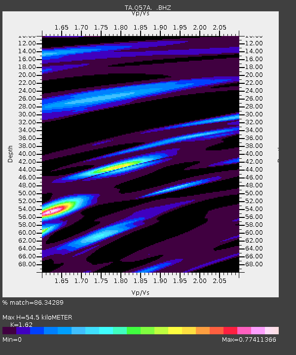
Q57A Strasburg, VA, USA - Earthquake Result Viewer

Earthquake location: Queen Charlotte Islands Region
Earthquake latitude/longitude: 51.2/-130.4
Earthquake time(UTC): 2013/09/03 (246) 20:19:06 GMT
Earthquake Depth: 2.7 km
Earthquake Magnitude: 6.1 MWW, 6.0 MWB, 6.1 MWW, 6.1 MWC, 6.2 MI, 6.2 MWC
Earthquake Catalog/Contributor: NEIC PDE/NEIC COMCAT
Network: TA USArray Transportable Network (new EarthScope stations)
Station: Q57A Strasburg, VA, USA
Lat/Lon: 39.04 N/78.41 W
Elevation: 324 m
Distance: 37.9 deg
Az: 88.019 deg
Baz: 306.237 deg
Ray Param: 0.075905114
Estimated Moho Depth: 54.5 km
Estimated Crust Vp/Vs: 1.62
Assumed Crust Vp: 6.159 km/s
Estimated Crust Vs: 3.802 km/s
Estimated Crust Poisson's Ratio: 0.19
Radial Match: 86.34289 %
Radial Bump: 325
Transverse Match: 41.07587 %
Transverse Bump: 400
SOD ConfigId: 626651
Insert Time: 2014-04-18 08:45:05.460 +0000
GWidth: 2.5
Max Bumps: 400
Tol: 0.001

Signal To Noise

ChannelStoNSTALTA
TA:Q57A: :BHZ:20130903T20:25:53.674991Z2.57261014.223803E-71.6418356E-7
TA:Q57A: :BHN:20130903T20:25:53.674991Z2.9427082.606659E-78.858027E-8
TA:Q57A: :BHE:20130903T20:25:53.674991Z3.411892.597634E-77.613475E-8
Arrivals
Ps5.9 SECOND
PpPs22 SECOND
PsPs/PpSs27 SECOND