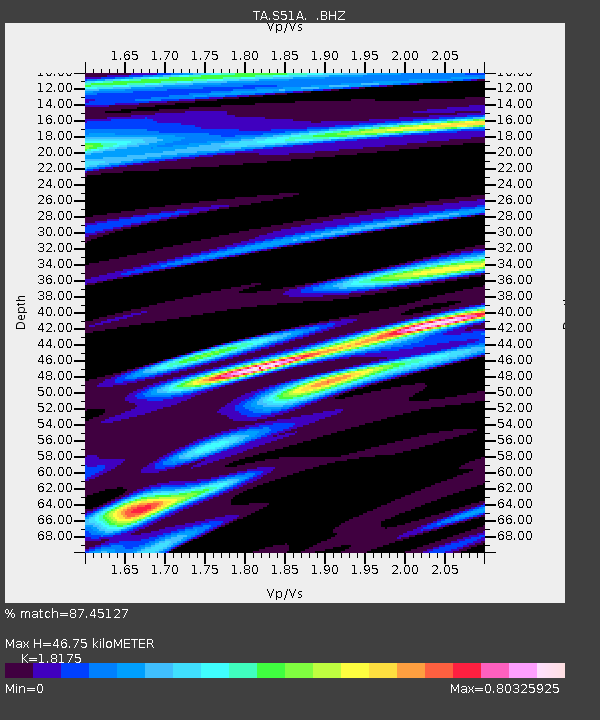
S51A Beattyville, KY, USA - Earthquake Result Viewer
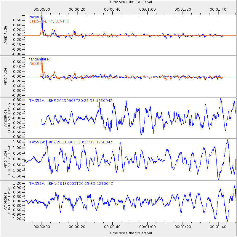
Earthquake location: Queen Charlotte Islands Region
Earthquake latitude/longitude: 51.2/-130.4
Earthquake time(UTC): 2013/09/03 (246) 20:19:06 GMT
Earthquake Depth: 2.7 km
Earthquake Magnitude: 6.1 MWW, 6.0 MWB, 6.1 MWW, 6.1 MWC, 6.2 MI, 6.2 MWC
Earthquake Catalog/Contributor: NEIC PDE/NEIC COMCAT
Network: TA USArray Transportable Network (new EarthScope stations)
Station: S51A Beattyville, KY, USA
Lat/Lon: 37.64 N/83.59 W
Elevation: 286 m
Distance: 35.5 deg
Az: 93.992 deg
Baz: 307.827 deg
Ray Param: 0.077229515
Estimated Moho Depth: 46.75 km
Estimated Crust Vp/Vs: 1.82
Assumed Crust Vp: 6.476 km/s
Estimated Crust Vs: 3.563 km/s
Estimated Crust Poisson's Ratio: 0.28
Radial Match: 87.45127 %
Radial Bump: 400
Transverse Match: 52.372982 %
Transverse Bump: 400
SOD ConfigId: 626651
Insert Time: 2014-04-18 08:45:47.452 +0000
GWidth: 2.5
Max Bumps: 400
Tol: 0.001

Signal To Noise

ChannelStoNSTALTA
TA:S51A: :BHZ:20130903T20:25:33.125004Z5.3574726.5646645E-71.2253288E-7
TA:S51A: :BHN:20130903T20:25:33.125004Z1.23593751.5010832E-71.2145301E-7
TA:S51A: :BHE:20130903T20:25:33.125004Z2.307122.9583953E-71.2822892E-7
Arrivals
Ps6.4 SECOND
PpPs19 SECOND
PsPs/PpSs25 SECOND