SFIN Lafayette, IN, USA - Earthquake Result Viewer
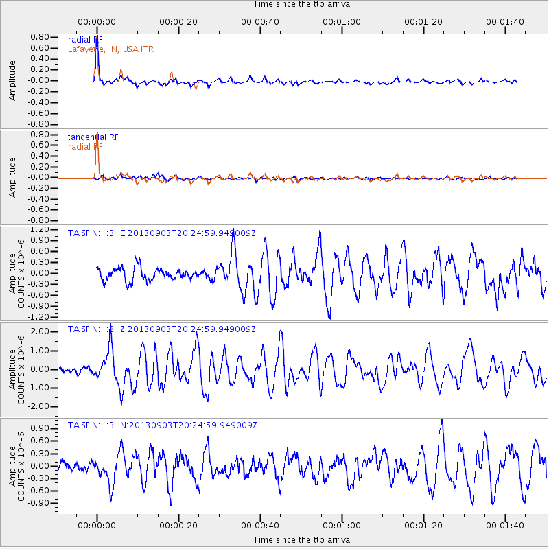
Earthquake location: Queen Charlotte Islands Region
Earthquake latitude/longitude: 51.2/-130.4
Earthquake time(UTC): 2013/09/03 (246) 20:19:06 GMT
Earthquake Depth: 2.7 km
Earthquake Magnitude: 6.1 MWW, 6.0 MWB, 6.1 MWW, 6.1 MWC, 6.2 MI, 6.2 MWC
Earthquake Catalog/Contributor: NEIC PDE/NEIC COMCAT
Network: TA USArray Transportable Network (new EarthScope stations)
Station: SFIN Lafayette, IN, USA
Lat/Lon: 40.38 N/87.10 W
Elevation: 165 m
Distance: 31.6 deg
Az: 92.926 deg
Baz: 304.741 deg
Ray Param: 0.07900505
Estimated Moho Depth: 50.0 km
Estimated Crust Vp/Vs: 1.60
Assumed Crust Vp: 6.498 km/s
Estimated Crust Vs: 4.061 km/s
Estimated Crust Poisson's Ratio: 0.18
Radial Match: 90.3569 %
Radial Bump: 314
Transverse Match: 65.14691 %
Transverse Bump: 400
SOD ConfigId: 626651
Insert Time: 2014-04-18 08:46:12.750 +0000
GWidth: 2.5
Max Bumps: 400
Tol: 0.001

Signal To Noise

ChannelStoNSTALTA
TA:SFIN: :BHZ:20130903T20:24:59.949009Z5.35801658.639974E-71.6125321E-7
TA:SFIN: :BHN:20130903T20:24:59.949009Z2.24298573.103042E-71.3834425E-7
TA:SFIN: :BHE:20130903T20:24:59.949009Z2.71933944.60794E-71.6945073E-7
Arrivals
Ps5.1 SECOND
PpPs18 SECOND
PsPs/PpSs23 SECOND