You are here: Home > Network List > TA - USArray Transportable Network (new EarthScope stations) Stations List
> Station P57A Homestead Farm, Martinsburg, WV, USA > Earthquake Result Viewer
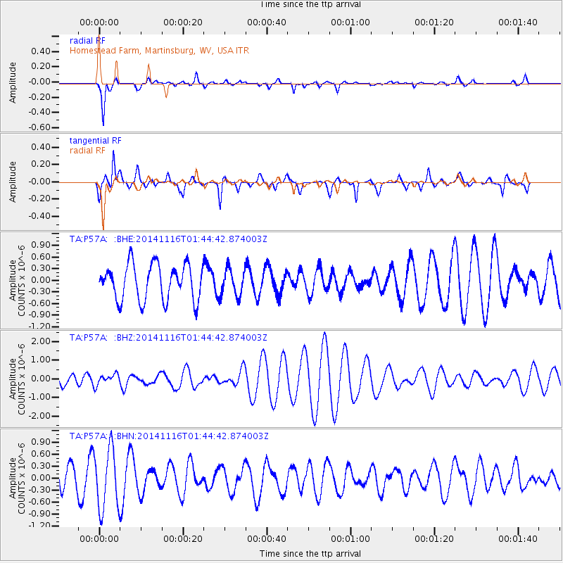
P57A Homestead Farm, Martinsburg, WV, USA - Earthquake Result Viewer
*The percent match for this event was below the threshold and hence no stack was calculated.
| Earthquake location: |
Iceland |
| Earthquake latitude/longitude: |
64.7/-17.6 |
| Earthquake time(UTC): |
2014/11/16 (320) 01:37:17 GMT |
| Earthquake Depth: |
10 km |
| Earthquake Magnitude: |
5.3 MW, 5.0 mb, 5.0 MS |
| Earthquake Catalog/Contributor: |
ISC/ISC |
|
| Network: |
TA USArray Transportable Network (new EarthScope stations) |
| Station: |
P57A Homestead Farm, Martinsburg, WV, USA |
| Lat/Lon: |
39.48 N/78.01 W |
| Elevation: |
191 m |
|
| Distance: |
42.6 deg |
| Az: |
263.867 deg |
| Baz: |
33.547 deg |
| Ray Param: |
$rayparam |
*The percent match for this event was below the threshold and hence was not used in the summary stack. |
|
| Radial Match: |
80.078636 % |
| Radial Bump: |
291 |
| Transverse Match: |
67.68642 % |
| Transverse Bump: |
389 |
| SOD ConfigId: |
3390531 |
| Insert Time: |
2019-04-15 00:51:14.355 +0000 |
| GWidth: |
2.5 |
| Max Bumps: |
400 |
| Tol: |
0.001 |
|
Signal To Noise
| Channel | StoN | STA | LTA |
| TA:P57A: :BHZ:20141116T01:44:42.874003Z | 0.5666581 | 2.6945781E-7 | 4.75521E-7 |
| TA:P57A: :BHN:20141116T01:44:42.874003Z | 2.8859804 | 7.5549104E-7 | 2.617797E-7 |
| TA:P57A: :BHE:20141116T01:44:42.874003Z | 0.75038975 | 3.4461587E-7 | 4.5924918E-7 |
| Arrivals |
| Ps | |
| PpPs | |
| PsPs/PpSs | |


